Development of the real estate data processing model based on modern GeoAI approaches
DOI:
https://doi.org/10.15587/2706-5448.2026.353171Keywords:
geographic information system, artificial intelligence, real estate, developer, stakeholder, machine learningAbstract
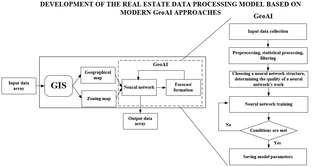
The object of the research is geographic information systems (GIS) used in the real estate market. Currently, a significant problem in analyzing market information is the absence of a geographic component when evaluating property costs. This deficiency leads to a simplified understanding of market processes, reduces assessment accuracy, and complicates forecasting methods. During the research, system analysis and geostatistics methods were used to transform data from a discrete to a continuous form. Adding a spatial component to property information and updating data online allows for identifying pattern chains and creating forecast scenarios in the shortest possible time. A generalized scheme for processing large data sets was developed in combination with the GeoAI algorithm flowchart. This allows for developing a full-fledged model of a geographic information system with an adaptive artificial intelligence function, enabling users to rapidly process information for making investment decisions. The article analyzes modern GIS with artificial intelligence functions used to solve various global real estate problems. The proposed a scheme for processing large data sets with GeoAI, reflecting the general structure of interaction between GIS, input/output data arrays, and a neural network used for analyzing and predicting spatial processes. Practical calculations have shown that by using GeoAI, the time for processing large data sets is reduced by more than 10 times.
References
- Kobzan, S., Pomortseva, O. (2023). Real Estate Market of Ukraine. Practical Aspects and Trends. SpringerBriefs in Geography, 146. https://doi.org/10.1007/978-3-031-31248-9
- Pomortseva, O., Kobzan, S., Pankiv, V., Kin, D. (2025). Principles for Creating an Intelligent Expert System for Real Estate Investment Analysis Based on Machine Learning and GIS. International Conference of Young Professionals «GeoTerrace-2025», 1–5. https://doi.org/10.3997/2214-4609.202552073
- Merkulova, T. V., Pomortseva, O. Е., Kobzan, S. M., Pankiv, V. V. (2025). Suchasnyi rynok nerukhomosti Ukrainy. Praktychni aspekty. Tendentsii ta perspektyvy rozvytku. ASSA, 212. Available at: https://acca.ua/product/suchasnyj-rynok-nerukhomosti-ukrayiny-praktychni-aspekty-tendentsiyi/
- Pavlov, K., Novosad, O., Semenov, N., Vozniuk, Y., Mishchuk, Y. (2024). The situation on the ukrainian residential real estate market in the pre-war and war periods. Energy Saving. Power Engineering. Energy Audit., 5 (195), 76–98. https://doi.org/10.20998/2313-8890.2024.05.06
- Lu, B., Ge, Y., Shi, Y., Zheng, J., Harris, P. (2023). Uncovering drivers of community-level house price dynamics through multiscale geographically weighted regression: A case study of Wuhan, China. Spatial Statistics, 53. https://doi.org/10.1016/j.spasta.2022.100723
- Tsutsumi, M., Shimada, A., Murakami, D. (2011). Land price maps of Tokyo Metropolitan Area. Procedia – Social and Behavioral Sciences, 21, 193–202. https://doi.org/10.1016/j.sbspro.2011.07.046
- Cienciała, A., Sobolewska-Mikulska, K., Sobura, S. (2021). Credibility of the cadastral data on land use and the methodology for their verification and update. Land Use Policy, 102. https://doi.org/10.1016/j.landusepol.2020.105204
- Chiarazzo, V., dell’Olio, L., Ibeas, Á., Ottomanelli, M. (2014). Modeling the Effects of Environmental Impacts and Accessibility on Real Estate Prices in Industrial Cities. Procedia – Social and Behavioral Sciences, 111, 460–469. https://doi.org/10.1016/j.sbspro.2014.01.079
- Droj, L., Droj, G. (2015). Usage of Location Analysis Software in the Evaluation of Commercial Real Estate Properties. Procedia Economics and Finance, 32, 826–832. https://doi.org/10.1016/s2212-5671(15)01525-7
- Afroosheh, S., Askari, M. (2024). Geospatial data fusion: Combining LiDAR, SAR, and optical imagery with AI for enhanced urban mapping. arXiv. https://doi.org/10.48550/arXiv.2412.18994
- Fauzi, C. (2024). A Review Geospatial Artificial Intelligence (GEO-AI): Implementation Of Machine Learning On Urban Planning. Jurnal Multidisiplin Indonesia, 3 (1), 3752–3765. https://doi.org/10.58344/jmi.v3i1.1057
- Zaychenko, Y., Starovoit, T. (2024). A hybrid model of artificial intelligence integrated into GIS for predicting accidents in water supply networks. System Research and Information Technologies, 2, 52–67. https://doi.org/10.20535/srit.2308-8893.2024.2.04
- Wang, S., Huang, X., Liu, P., Zhang, M., Biljecki, F., Hu, T. et al. (2024). Mapping the landscape and roadmap of geospatial artificial intelligence (GeoAI) in quantitative human geography: An extensive systematic review. International Journal of Applied Earth Observation and Geoinformation, 128, 103734. https://doi.org/10.1016/j.jag.2024.103734
- GeoAI. Available at: https://geoai.au/
- Geospatial AI. Artificial intelligence in Gis. Esri. Available at: https://www.esri.com/en-us/artificial-intelligence/overview
- Brooks, P. (2019). Honolulu Planners Visualize Housing Patterns with an Eye on Affordability. Esri. Available at: https://www.esri.com/about/newsroom/blog/honolulu-planners-visualize-urban-development-patterns/
- From Index to Insights: Uncovering Vilnius’ Urban Transformation. Mayors of Europe. Available at: https://mayorsofeurope.eu/news/from-index-to-insights-uncovering-vilnius-urban-transformation/
- Pomortseva, О. Ye., Nalivayko, T. A., Kozyrenko, V. P., Pyskun, V. K. (2025). A Geoinformation Research of the Real Estate Market in Ukraine Using Spatial Databases. Business Inform, 7 (569), 116–122. https://doi.org/10.32983/2222-4459-2025-7-116-122
- LUN. Available at: https://misto.lun.ua/stat/kyiv
- UVECON. Geoportal. Available at: https://gisuvecon.com/main/geoportal/
Downloads
Published
How to Cite
Issue
Section
License
Copyright (c) 2026 Sergiy Kobzan, Olena Pomortseva, Volodymyr Pankiv

This work is licensed under a Creative Commons Attribution 4.0 International License.
The consolidation and conditions for the transfer of copyright (identification of authorship) is carried out in the License Agreement. In particular, the authors reserve the right to the authorship of their manuscript and transfer the first publication of this work to the journal under the terms of the Creative Commons CC BY license. At the same time, they have the right to conclude on their own additional agreements concerning the non-exclusive distribution of the work in the form in which it was published by this journal, but provided that the link to the first publication of the article in this journal is preserved.