Enhancing accuracy of information processing in onboard subsystems of UAVs
DOI:
https://doi.org/10.15587/2706-5448.2023.287700Keywords:
LeGNSS, INS, LEO satellites, UAV, multi-constellation positioning system, precise positioning, drone managementAbstract
The object of research is the onboard subsystems of Unmanned Aerial Vehicles (UAVs). The research is aimed at analyzing UAVs, specifically the integration and enhancement of satellite-based positioning systems, including Global Navigation Satellite Systems (GNSS) and Inertial Navigation Systems (INS).
The problem concerns traditional satellite-based positioning services, especially those relying solely on medium earth orbit (MEO) satellites, which are insufficient for specific requirements. The study aims to address the limitations of these systems on onboard subsystems of UAVs, especially in challenging environments laden with jammers and interference, and to provide a more accurate, robust, and continuous positioning solution.
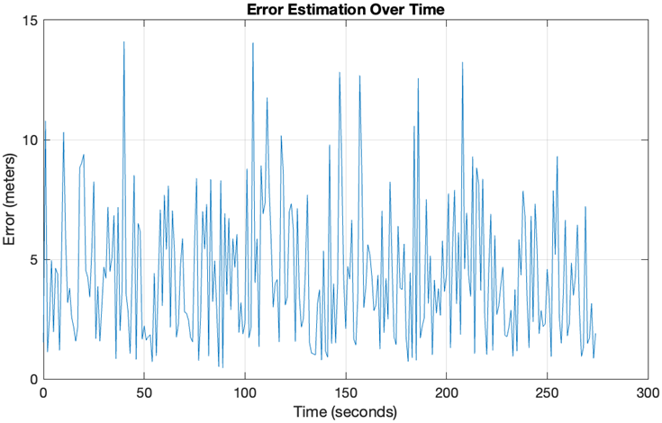
The research proposes a «multilayer system of systems» approach that integrates signals from various sources, including low Earth orbit (LEO) satellites, ground-based positioning, navigation, and timing (PNT) systems, and user-centric sensors. The combined approach, termed LeGNSS/INS, leverages the strengths of each component, providing redundancy and enhanced accuracy. The system's performance was evaluated using pseudo-real output data, demonstrating its ability to generate quasi-real dynamic trajectories for UAV flight. The error analysis showed that the proposed method consistently outperforms traditional GNSS systems, especially in challenging environments.
The enhanced performance of the LeGNSS/INS system can be attributed to integrating multiple satellite systems with INS and applying optimal filtering techniques. The research also employed mathematical modeling to represent the dependencies and interactions when combining data from different sources, such as GPS, LEO, and INS. The Kalman filter is a mechanism to fuse data from multiple sources optimally.
The insights from this study apply to various sectors, including aviation, maritime navigation, autonomous drones, and defense. The enhanced positioning accuracy can significantly improve safety, navigation precision, and operational efficiency. However, the study assumes idealized conditions for satellite signal reception, which might not always be accurate in real-world scenarios. Challenges, such as the martial law conditions in Ukraine affecting data collection and potential satellite signal restrictions, were also highlighted. Further research can delve into the impact of more complex environmental factors and the integration of additional satellite systems or sensors to enhance accuracy further.
References
- Bryson, M., Sukkarieh, S. (2015). UAV Localization Using Inertial Sensors and Satellite Positioning Systems. Handbook of Unmanned Aerial Vehicles. Dordrecht: Springer, 433–460. doi: https://doi.org/10.1007/978-90-481-9707-1_3
- Won, J. H., Pany, T. (2017). Signal Processing. Springer Handbook of Global Navigation Satellite Systems. Cham: Springer, 401–442. doi: https://doi.org/10.1007/978-3-319-42928-1_14
- Elkaim, G. H., Lie, F. A. P., Gebre-Egziabher, D.; Valavanis, K., Vachtsevanos, G. (Eds.) (2015). Principles of Guidance, Navigation, and Control of UAVs. Handbook of Unmanned Aerial Vehicles. Dordrecht: Springer, 347–380. doi: https://doi.org/10.1007/978-90-481-9707-1_56
- Jardak, N., Jault, Q. (2022). The Potential of LEO Satellite-Based Opportunistic Navigation for High Dynamic Applications. Sensors, 22 (7), 2541. doi: https://doi.org/10.3390/s22072541
- Kogure, S., Ganeshan, A., Montenbruck, O.; Teunissen, P. J., Montenbruck, O. (Eds.) (2017). Regional Systems. Springer Handbook of Global Navigation Satellite Systems. Cham: Springer, 305–337. doi: https://doi.org/10.1007/978-3-319-42928-1_11
- Vasyliev, V. M., Rogozhyn, V. O., Dolintse, B. I. (2015). Integration of inertial and satellite navigation systems using corrective circuits for UAV. 2015 IEEE APUAVD. Kyiv, 193–197. doi: https://doi.org/10.1109/apuavd.2015.7346597
- Maya, D., Gallego, Z., Zaid, R., Kouedjin, K. Y., Sarri, P., Guinamard, A. (2021). Tightly Coupled Integration of Inertial Data with Multi-Constellation PPP-IF with Integer Ambiguity Resolution. Proceedings of the 34th ION GNSS+ 2021. St. Louis, 2879–2894. doi: https://doi.org/10.33012/2021.18023
- Li, T., Zhang, H., Gao, Z., Chen, Q., Niu, X. (2018). High-Accuracy Positioning in Urban Environments Using Single-Frequency Multi-GNSS RTK/MEMS-IMU Integration. Remote Sensing, 10 (2), 205. doi: https://doi.org/10.3390/rs10020205
- Reuper, B., Becker, M., Leinen, S. (2018). Benefits of Multi-Constellation/Multi-Frequency GNSS in a Tightly Coupled GNSS/IMU/Odometry Integration Algorithm. Sensors, 18 (9), 3052. doi: https://doi.org/10.3390/s18093052
- Chen, Z., Li, J., Luo, J., Cao, X. (2018). A New Strategy for Extracting ENSO Related Signals in the Troposphere and Lower Stratosphere from GNSS RO Specific Humidity Observations. Remote Sensing, 10 (4), 503. doi: https://doi.org/10.3390/rs10040503
- Zhang, P., Tu, R., Zhang, R., Gao, Y., Cai, H. (2018). Combining GPS, BeiDou, and Galileo Satellite Systems for Time and Frequency Transfer Based on Carrier Phase Observations. Remote Sensing, 10 (2), 324. doi: https://doi.org/10.3390/rs10020324
- Swaminathan, H. B., Sommer, A., Becker, A., Atzmueller, M. (2022). Performance Evaluation of GNSS Position Augmentation Methods for Autonomous Vehicles in Urban Environments. Sensors, 22 (21), 8419. doi: https://doi.org/10.3390/s22218419
- Elghamrawy, H., Karaim, M., Tamazin, M., Noureldin, A. (2020). Experimental Evaluation of the Impact of Different Types of Jamming Signals on Commercial GNSS Receivers. Applied Sciences, 10 (12), 4240. doi: https://doi.org/10.3390/app10124240
- del Portillo, I., Cameron, B. G., Crawley, E. F. (2019). A technical comparison of three low earth orbit satellite constellation systems to provide global broadband. Acta Astronautica, 159, 123–135. doi: https://doi.org/10.1016/j.actaastro.2019.03.040
- Xu, X., Wang, C., Jin, Z. (2022). An analysis method for ISL of multilayer constellation. Journal of Systems Engineering and Electronics, 33 (4), 961–968. doi: https://doi.org/10.23919/jsee.2022.000093
- Singh, L. A., Whittecar, W. R., DiPrinzio, M. D., Herman, J. D., Ferringer, M. P., Reed, P. M. (2020). Low cost satellite constellations for nearly continuous global coverage. Nature Communications, 11 (1). doi: https://doi.org/10.1038/s41467-019-13865-0
- Wang, J., Zhou, Z., Jiang, W., Cai, B., Shangguan, W.; Sun, J., Yang, C., Xie, J. (Eds.) (2020). A Multi-constellation Positioning Method Based on Optimal Stochastic Modelling. China Satellite Navigation Conference (CSNC) 2020 Proceedings: Vol. I. CSNC 2020. Lecture Notes in Electrical Engineering. Singapore: Springer, 358–367. doi: https://doi.org/10.1007/978-981-15-3707-3_34
- Tomaštík, J., Chudá, J., Tunák, D., Chudý, F., Kardoš, M. (2020). Advances in smartphone positioning in forests: dual-frequency receivers and raw GNSS data. Forestry: An International Journal of Forest Research, 94 (2), 292–310. doi: https://doi.org/10.1093/forestry/cpaa032
- Yang, Y., Liu, L., Li, J., Yang, Y., Zhang, T., Mao, Y., Sun, B., Ren, X. (2021). Featured services and performance of BDS-3. Science Bulletin, 66 (20), 2135–2143. doi: https://doi.org/10.1016/j.scib.2021.06.013
- Zhu, H., Xia, L., Wu, D., Xia, J., Li, Q. (2020). Study on Multi-GNSS Precise Point Positioning Performance with Adverse Effects of Satellite Signals on Android Smartphone. Sensors, 20 (22), 6447. doi: https://doi.org/10.3390/s20226447
- Jardak, N., Adam, R. (2023). Practical Use of Starlink Downlink Tones for Positioning. Sensors, 23 (6), 3234. doi: https://doi.org/10.3390/s23063234
- Neinavaie, M., Kassas, Z. M. (2023). Unveiling Starlink LEO Satellite OFDM-Like Signal Structure Enabling Precise Positioning. IEEE Transactions on Aerospace and Electronic Systems, 1–4. doi: https://doi.org/10.1109/taes.2023.3265951
Downloads
Published
How to Cite
Issue
Section
License
Copyright (c) 2023 Igor Zhukov, Bogdan Dolintse

This work is licensed under a Creative Commons Attribution 4.0 International License.
The consolidation and conditions for the transfer of copyright (identification of authorship) is carried out in the License Agreement. In particular, the authors reserve the right to the authorship of their manuscript and transfer the first publication of this work to the journal under the terms of the Creative Commons CC BY license. At the same time, they have the right to conclude on their own additional agreements concerning the non-exclusive distribution of the work in the form in which it was published by this journal, but provided that the link to the first publication of the article in this journal is preserved.