Розроблення нейромережевого методу оцінки стану зруйнованих будівель за зображеннями з безпілотних літальних апаратів
DOI:
https://doi.org/10.15587/1729-4061.2026.351605Ключові слова:
БПЛА, аерофотознімки, YOLO, ViT, нейромережева класифікація руйнувань, оцінювання пошкоджень будівельАнотація
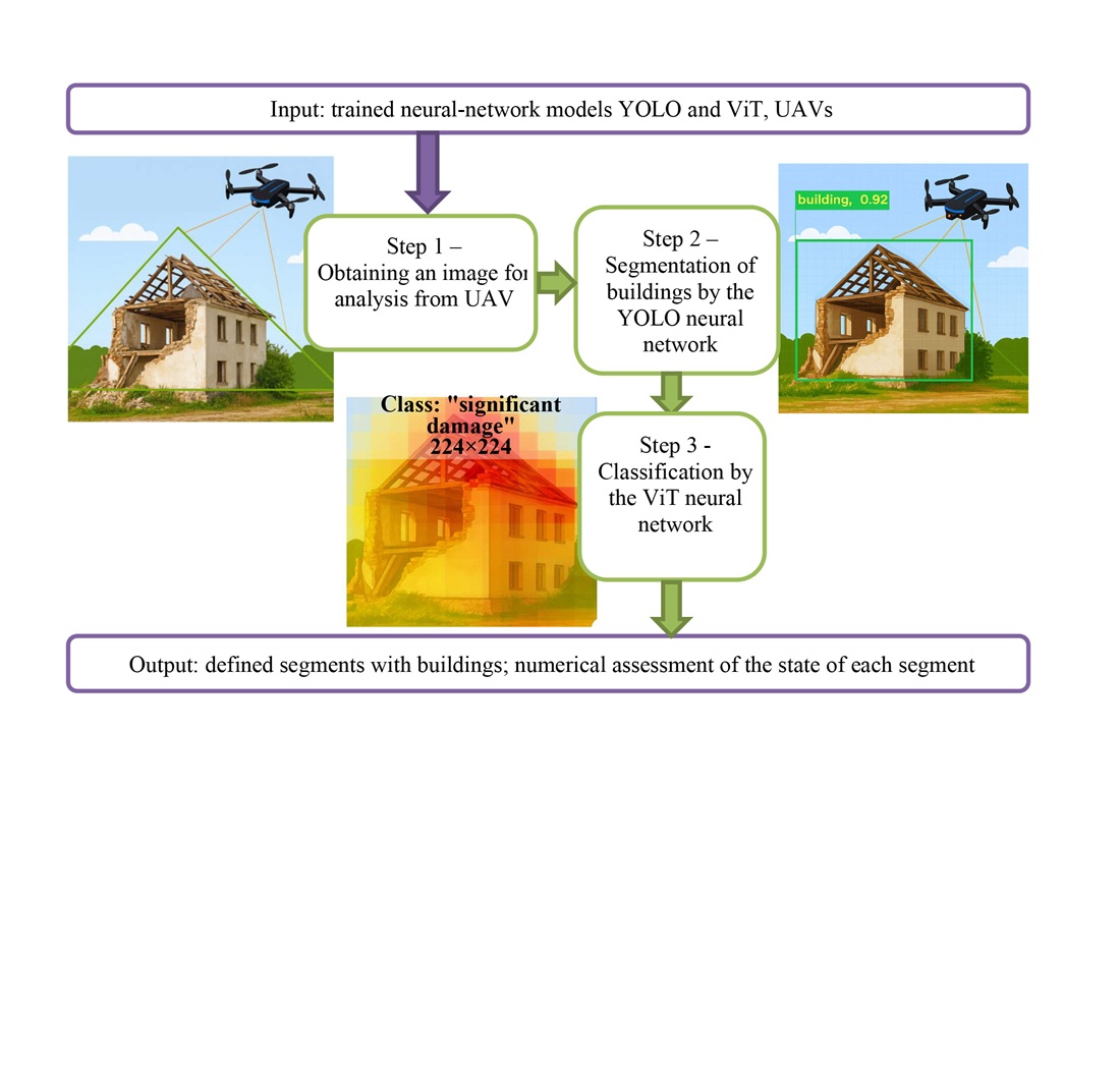
Об’єктом дослідження є процес оцінювання стану зруйнованих будівель за аерофотознімками з безпілотних літальних апаратів (БПЛА). Проблема, що вирішувалась: післявоєнний моніторинг територій ускладнюється обсягом супутникових і БПЛА-знімків, що перевищує можливості огляду експертом, а відсутність інструментів однорідної інтерпретації та доменний зсув знижують відтворюваність оцінювання. Запропонований двоетапний нейромережевий метод поєднує сегментацію забудови та визначення рівня руйнування будівель за чотирирівневою шкалою пошкоджень: «відсутні», «незначні», «значні», «зруйновано». Як вихідний матеріал застосовано корпус «xView2», доповнений власними розміченими знімками з БПЛА.
Для виділення контурів будівель застосовано сегментаційні моделі «You Only Look Once» (YOLO) версій v8s і v11n, а для класифікації пошкоджень – Vision Transformer (ViT). Експерименти виконано в Google Colab (США) з використанням PyTorch (США) та Ultralytics (Велика Британія). Для сегментаційних моделей обчислено Mean Average Precision (mAP). Показники mAP залишаються прийнятними навіть у складних урбанізованих сценах.
Для класифікаційної моделі ViT отримано значення Precision, Recall та F1-міри понад 0.9. Досягнуті значення пояснюються поєднанням двоетапної архітектури та балансуванням вибірки.
Розроблений метод застосовний до супутникових і БПЛА-знімків, на відміну від існуючих рішень, зберігає стійкість при доменному зсуві. Отримані моделі можуть бути впроваджені як базовий модуль геоінформаційних систем та систем підтримки прийняття рішень, забезпечуючи практичне використання результатів роботи. Для коректної роботи необхідні достатня роздільна здатність та репрезентативність навчальної вибірки
Посилання
- Mazurets, O., Sobko, O., Dydo, R., Zalutska, O., Molchanova, M. (2025). Augmented reality audiostream creation using CNN: boosting inclusion and safety for visually impaired people. CEUR Workshop Proceedings, 4004, 347–361. Available at: https://ceur-ws.org/Vol-4004/paper26.pdf
- Krak, I., Sobko, O., Molchanova, M., Tymofiiev, I., Mazurets, O., Barmak, O. (2025). Method for neural network cyberbullying detection in text content with visual analytic. CEUR Workshop Proceedings, 3917, 298–309. Available at: https://ceur-ws.org/Vol-3917/paper57.pdf
- Gu, J., Xie, Z., Zhang, J., He, X. (2024). Advances in Rapid Damage Identification Methods for Post-Disaster Regional Buildings Based on Remote Sensing Images: A Survey. Buildings, 14 (4), 898. https://doi.org/10.3390/buildings14040898
- Xia, H., Wu, J., Yao, J., Zhu, H., Gong, A., Yang, J. et al. (2023). A Deep Learning Application for Building Damage Assessment Using Ultra-High-Resolution Remote Sensing Imagery in Turkey Earthquake. International Journal of Disaster Risk Science, 14 (6), 947–962. https://doi.org/10.1007/s13753-023-00526-6
- Singh, D. K., Hoskere, V. (2023). Post Disaster Damage Assessment Using Ultra-High-Resolution Aerial Imagery with Semi-Supervised Transformers. Sensors, 23 (19), 8235. https://doi.org/10.3390/s23198235
- Tennant, E., Jenkins, S. F., Miller, V., Robertson, R., Wen, B., Yun, S.-H., Taisne, B. (2024). Automating tephra fall building damage assessment using deep learning. Natural Hazards and Earth System Sciences, 24 (12), 4585–4608. https://doi.org/10.5194/nhess-24-4585-2024
- Alsaaran, N., Soudani, A. (2025). Deep Learning Image-Based Classification for Post-Earthquake Damage Level Prediction Using UAVs. Sensors, 25 (17), 5406. https://doi.org/10.3390/s25175406
- Zhuang, X., Tran, T. V., Nguyen-Xuan, H., Rabczuk, T. (2025). Deep learning-based post-earthquake structural damage level recognition. Computers & Structures, 315, 107761 https://doi.org/10.1016/j.compstruc.2025.107761
- Lyu, C., Lin, S., Lynch, A., Zou, Y., Liarokapis, M. (2025). UAV-based deep learning applications for automated inspection of civil infrastructure. Automation in Construction, 177, 106285. https://doi.org/10.1016/j.autcon.2025.106285
- Zha, Q., Yao, Y., Zheng, Y., Ma, W., Zhang, W. (2025). A dataset of building surface defects collected by UAVs for machine learning-based detection. Scientific Data, 12 (1). https://doi.org/10.1038/s41597-025-06318-5
- Molchanova, M., Didur, V., Mazurets, O., Sobko, O., Zakharkevich, O. (2025). Method for construction and demolition waste classification using two-factor neural network image analysis. CEUR Workshop Proceedings, 3970, 168–182. Available at: https://ceur-ws.org/Vol-3970/PAPER14.pdf
- xView2 Challenge Dataset - train and test. Available at: https://www.kaggle.com/datasets/tunguz/xview2-challenge-dataset-train-and-test/data
- Sobko, O., Mazurets, O., Molchanova, M., Krak, I., Barmak, O. (2025). Method for analysis and formation of representative text datasets. CEUR Workshop Proceedings, 3899, 84–98. Available at: https://ceur-ws.org/Vol-3899/paper9.pdf
- Asif, A., Rafique, H., Jadoon, K., Zakwan, M., Mahmood, M. H. (2024). Change-centric building damage assessment across multiple disasters using deep learning. International Journal of Data Science and Analytics, 20 (3), 1915–1931. https://doi.org/10.1007/s41060-024-00577-y
##submission.downloads##
Опубліковано
Як цитувати
Номер
Розділ
Ліцензія
Авторське право (c) 2026 Oleksandr Mazurets, Maryna Molchanova, Maksim Shurypa, Olena Sobko

Ця робота ліцензується відповідно до Creative Commons Attribution 4.0 International License.
Закріплення та умови передачі авторських прав (ідентифікація авторства) здійснюється у Ліцензійному договорі. Зокрема, автори залишають за собою право на авторство свого рукопису та передають журналу право першої публікації цієї роботи на умовах ліцензії Creative Commons CC BY. При цьому вони мають право укладати самостійно додаткові угоди, що стосуються неексклюзивного поширення роботи у тому вигляді, в якому вона була опублікована цим журналом, але за умови збереження посилання на першу публікацію статті в цьому журналі.
Ліцензійний договір – це документ, в якому автор гарантує, що володіє усіма авторськими правами на твір (рукопис, статтю, тощо).
Автори, підписуючи Ліцензійний договір з ПП «ТЕХНОЛОГІЧНИЙ ЦЕНТР», мають усі права на подальше використання свого твору за умови посилання на наше видання, в якому твір опублікований. Відповідно до умов Ліцензійного договору, Видавець ПП «ТЕХНОЛОГІЧНИЙ ЦЕНТР» не забирає ваші авторські права та отримує від авторів дозвіл на використання та розповсюдження публікації через світові наукові ресурси (власні електронні ресурси, наукометричні бази даних, репозитарії, бібліотеки тощо).
За відсутності підписаного Ліцензійного договору або за відсутністю вказаних в цьому договорі ідентифікаторів, що дають змогу ідентифікувати особу автора, редакція не має права працювати з рукописом.
Важливо пам’ятати, що існує і інший тип угоди між авторами та видавцями – коли авторські права передаються від авторів до видавця. В такому разі автори втрачають права власності на свій твір та не можуть його використовувати в будь-який спосіб.