Developing satellite hyperspectral image processing using a maximum abundance classifier with nine ground truth classes
DOI:
https://doi.org/10.15587/1729-4061.2023.271774Keywords:
hyperspectral image processing, maximum abundance classifier, ground truth, satellite mapsAbstract
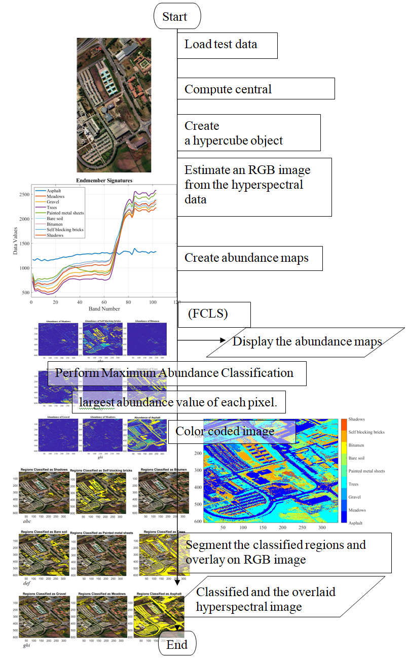
In the hundreds of bands of the photographed substance, hyperspectral imaging delivers a great density of spectral data. This allows the images to be used for a variety of purposes, including agriculture, geosciences, and biomedical imaging. Previous work didn’t discuss the best classifier with sufficient ground truth classes. This work presents the application of maximum abundance classification (MAC) for classifying a variety of areas over hyperspectral images. The allocation of an end-member throughout hyperspectral images can be described with abundance maps. Since each pixel's abundance values represent the proportion of each end-member that is present in that pixel, the pixels in a hyperspectral image will be classified in this study by determining the highest abundance rate of every pixel and allocating it to the corresponding end-member category. The ground truth classes are represented by nine end-members in the test data: Bitumen, Shadows, Self-Blocking Bricks, Bare Soil, highlighted Metal area, Gravel, Meadows, Trees, and Asphalt. By uniformly distributing the range of wavelength over the amount of spectral domains, we initially determine the central wavelength for each band to visualize loaded data and the end-member signatures of nine ground truth classes. Next, we estimate the end-members abundance maps. Finally, we classify the Max Abundance of every pixel to present a color-coded image, the overlaid, and the classified hyperspectral image areas over their category labels. The result demonstrates that brick, bare soil, trees, and asphalt zones have all been correctly identified in the photographs, which is beneficial for the identification or detection of materials
Supporting Agency
- The authors would like to express their deepest gratitude to the Department of Clinical Laboratory Sciences, College of Pharmacy, University of Mosul-Iraq for their support to complete this research.
References
- Sarić, R., Nguyen, V. D., Burge, T., Berkowitz, O., Trtílek, M., Whelan, J. et al. (2022). Applications of hyperspectral imaging in plant phenotyping. Trends in Plant Science, 27 (3), 301–315. doi: https://doi.org/10.1016/j.tplants.2021.12.003
- Sugawara, S., Sugizaki, S., Nakayama, Y., Taniguchi, H., Ishimaru, I. (2021). Preliminary study for detection of adhesive on a painted ceramic plate and varnish on printed paper using near-infrared hyperspectral imaging at wavelengths of 1.0–2.35 µm. Infrared Physics & Technology, 117, 103809. doi: https://doi.org/10.1016/j.infrared.2021.103809
- Xue, Q., Qi, M., Li, Z., Yang, B., Li, W., Wang, F., Li, Q. (2021). Fluorescence hyperspectral imaging system for analysis and visualization of oil sample composition and thickness. Applied Optics, 60 (27), 8349. doi: https://doi.org/10.1364/ao.432851
- Shijer, S. S., Sabry, A. H. (2021). Analysis of performance parameters for wireless network using switching multiple access control method. Eastern-European Journal of Enterprise Technologies, 4 (9 (112)), 6–14. doi: https://doi.org/10.15587/1729-4061.2021.238457
- Mohammed, A. B., Al-Mafrji, A. A. M., Yassen, M. S., Sabry, A. H. (2022). Developing plastic recycling classifier by deep learning and directed acyclic graph residual network. Eastern-European Journal of Enterprise Technologies, 2 (10 (116)), 42–49. doi: https://doi.org/10.15587/1729-4061.2022.254285
- Guda, M., Gasser, S., El-Mahallawy, M. S., Shehata, K. (2020). FPGA Implementation of L1/2 Sparsity Constrained Nonnegative Matrix Factorization Algorithm for Remotely Sensed Hyperspectral Image Analysis. IEEE Access, 8, 12069–12083. doi: https://doi.org/10.1109/access.2020.2966044
- Gao, L., Zhang, B., Sun, X., Li, S., Du, Q., Wu, C. (2013). Optimized maximum noise fraction for dimensionality reduction of Chinese HJ-1A hyperspectral data. EURASIP Journal on Advances in Signal Processing, 2013 (1). doi: https://doi.org/10.1186/1687-6180-2013-65
- Lv, N., Han, Z., Chen, C., Feng, Y., Su, T., Goudos, S., Wan, S. (2021). Encoding Spectral-Spatial Features for Hyperspectral Image Classification in the Satellite Internet of Things System. Remote Sensing, 13 (18), 3561. doi: https://doi.org/10.3390/rs13183561
- Iyer, P., A, S., Lal, S. (2021). Deep learning ensemble method for classification of satellite hyperspectral images. Remote Sensing Applications: Society and Environment, 23, 100580. doi: https://doi.org/10.1016/j.rsase.2021.100580
- Hagag, A., Fan, X., Abd El-Samie, F. E. (2017). HyperCast: Hyperspectral satellite image broadcasting with band ordering optimization. Journal of Visual Communication and Image Representation, 42, 14–27. doi: https://doi.org/10.1016/j.jvcir.2016.11.006
- Arellano, P., Tansey, K., Balzter, H., Boyd, D. S. (2015). Detecting the effects of hydrocarbon pollution in the Amazon forest using hyperspectral satellite images. Environmental Pollution, 205, 225–239. doi: https://doi.org/10.1016/j.envpol.2015.05.041
- Shin, J., Kim, K., Ryu, J.-H. (2020). Comparative study on hyperspectral and satellite image for the estimation of chlorophyll a concentration on coastal areas. Korean Journal of Remote Sensing, 36 (2_2), 309–323. doi: https://doi.org/10.7780/kjrs.2020.36.2.2.7
- Yang, M.-D., Huang, K.-H., Tsai, H.-P. (2020). Integrating MNF and HHT Transformations into Artificial Neural Networks for Hyperspectral Image Classification. Remote Sensing, 12 (14), 2327. doi: https://doi.org/10.3390/rs12142327
- Huang, H., Chen, M., Duan, Y. (2019). Dimensionality Reduction of Hyperspectral Image Using Spatial-Spectral Regularized Sparse Hypergraph Embedding. Remote Sensing, 11 (9), 1039. doi: https://doi.org/10.3390/rs11091039
- Veligandan, S. K., Rengasari, N. (2018). Hyperspectral image segmentation based on enhanced estimation of centroid with fast K-means. The International Arab Journal of Information Technology, 15 (5), 904–911. Available at: https://iajit.org/portal/PDF/September%202018,%20No.%205/10400.pdf
- Lin, L., Chen, C., Xu, T. (2020). Spatial-spectral hyperspectral image classification based on information measurement and CNN. EURASIP Journal on Wireless Communications and Networking, 2020 (1). doi: https://doi.org/10.1186/s13638-020-01666-9
Downloads
Published
How to Cite
Issue
Section
License
Copyright (c) 2023 Ghassan Ahmad Ismaeel, Mina Basheer Gheni, Saad Qasim Abbas, Mustafa Musa Jaber, Mohammed Hasan Ali

This work is licensed under a Creative Commons Attribution 4.0 International License.
The consolidation and conditions for the transfer of copyright (identification of authorship) is carried out in the License Agreement. In particular, the authors reserve the right to the authorship of their manuscript and transfer the first publication of this work to the journal under the terms of the Creative Commons CC BY license. At the same time, they have the right to conclude on their own additional agreements concerning the non-exclusive distribution of the work in the form in which it was published by this journal, but provided that the link to the first publication of the article in this journal is preserved.
A license agreement is a document in which the author warrants that he/she owns all copyright for the work (manuscript, article, etc.).
The authors, signing the License Agreement with TECHNOLOGY CENTER PC, have all rights to the further use of their work, provided that they link to our edition in which the work was published.
According to the terms of the License Agreement, the Publisher TECHNOLOGY CENTER PC does not take away your copyrights and receives permission from the authors to use and dissemination of the publication through the world's scientific resources (own electronic resources, scientometric databases, repositories, libraries, etc.).
In the absence of a signed License Agreement or in the absence of this agreement of identifiers allowing to identify the identity of the author, the editors have no right to work with the manuscript.
It is important to remember that there is another type of agreement between authors and publishers – when copyright is transferred from the authors to the publisher. In this case, the authors lose ownership of their work and may not use it in any way.


