Розробка двохетапного методу сегментування кольорових зображень урбанізованої місцевості з космічних оптико-електронних систем спостереження на основі мурашиного алгоритму та алгоритму Хафа
DOI:
https://doi.org/10.15587/1729-4061.2023.274360Ключові слова:
сегментування зображення, урбанізована місцевість, мурашиний алгоритм, алгоритм Хафа, космічна системаАнотація
Об’єктом дослідження є високий рівень помилок першого та другого роду сегментування зображень урбанізованої місцевості з космічних оптико-електронних систем спостереження.
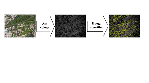
Метод сегментування зображень урбанізованої місцевості передбачає двохетапність та, на відміну від відомих:
– враховує кожний канал яскравості кольорового простору вихідного зображення;
– на першому етапі використовується мурашиний алгоритм;
– сегментування зображення на першому етапі зводиться до розрахунку цільової функції, ділянок руху мурах та концентрації феромону на маршрутах руху мурах.
– на другому етапі враховуються яскравість та геометрична форма елементів об’єктів;
– визначаються контури та геометричні примітиви у параметричному просторі Хафа;
– визначаються об’єкти інтересу урбанізованої місцевості у просторі вихідного зображення.
Проведено експериментальне дослідження сегментування зображень урбанізованої місцевості з космічних оптико-електронних систем спостереження на основі мурашиного алгоритму та алгоритму Хафа.
Проведено оцінювання якості сегментування зображення урбанізованої місцевості. Встановлено, що помилка І роду при використанні удосконаленого методу сегментування зменшується на 2,75 %. Помилка ІІ роду при використанні удосконаленого методу сегментування зменшується на 3,91 %. Таке зменшення стало можливим за рахунок застосування на першому етапі удосконаленого методу сегментування зображення урбанізованої місцевості мурашиного алгоритму. У порівнянні з алгоритмом Канні помилка І роду зменшилася на 8,9 %, а помилка ІІ роду зменшилася на 11,0 %.
Методи сегментування зображень урбанізованої місцевості з космічних оптико-електронних систем спостереження можуть бути реалізовані у програмно-технічних комплексах обробки зображень
Посилання
- Chemin, Y. (Ed.) (2012). Remote Sensing of Planet Earth. IntechOpen, 252. doi: https://doi.org/10.5772/2291
- Richards, J. (2022). Remote Sensing Digital Image Analysis. Springer, 567. doi: https://doi.org/10.1007/978-3-030-82327-6
- Cheng, G., Han, J. (2016). A survey on object detection in optical remote sensing images. ISPRS Journal of Photogrammetry and Remote Sensing, 117, 11–28. doi: https://doi.org/10.1016/j.isprsjprs.2016.03.014
- Pultarova, T. New satellite photos show surface cracks from devastating Turkey earthquake. Available at: https://www.space.com/turkey-earthquakes-damage-maxar-satellite-photos
- Satellite images show Bakhmut before and after Russian invasion. Available at: https://news.yahoo.com/satellite-images-show-bakhmut-russian-055820360.html
- Harrison, T., Strohmeyer, M. (2022). Commercial Space Remote Sensing and Its Role in National Security. Center for Strategic & International Studies. Available at: https://csis-website-prod.s3.amazonaws.com/s3fs-public/publication/220202_Harrison_Commercial_Space.pdf?VgV9.43i5ZGs8JDAYDtz0KNbkEnXpH21
- Khudov, H., Makoveichuk, O., Butko, I., Butko, M., Khudolei, V., Kukhtyk, S. (2022). The development of a management decision-making method based on the analysis of information from space observation systems. Eastern-European Journal of Enterprise Technologies, 6 (9 (120)), 59–69. doi: https://doi.org/10.15587/1729-4061.2022.269027
- Abdollahi, A., Pradhan, B. (2021). Integrated technique of segmentation and classification methods with connected components analysis for road extraction from orthophoto images. Expert Systems with Applications, 176, 114908. doi: https://doi.org/10.1016/j.eswa.2021.114908
- Bakhtiari, H. R. R., Abdollahi, A., Rezaeian, H. (2017). Semi automatic road extraction from digital images. The Egyptian Journal of Remote Sensing and Space Science, 20 (1), 117–123. doi: https://doi.org/10.1016/j.ejrs.2017.03.001
- Senthilnath, J., Rajeshwari, M., Omkar, S. N. (2009). Automatic road extraction using high resolution satellite image based on texture progressive analysis and normalized cut method. Journal of the Indian Society of Remote Sensing, 37 (3), 351–361. doi: https://doi.org/10.1007/s12524-009-0043-5
- Singh, P. P., Garg, R. D. (2013). Automatic Road Extraction from High Resolution Satellite Image using Adaptive Global Thresholding and Morphological Operations. Journal of the Indian Society of Remote Sensing, 41 (3), 631–640. doi: https://doi.org/10.1007/s12524-012-0241-4
- Miao, Z., Shi, W., Gamba, P., Li, Z. (2015). An Object-Based Method for Road Network Extraction in VHR Satellite Images. IEEE Journal of Selected Topics in Applied Earth Observations and Remote Sensing, 8 (10), 4853–4862. doi: https://doi.org/10.1109/jstars.2015.2443552
- Grinias, I., Panagiotakis, C., Tziritas, G. (2016). MRF-based segmentation and unsupervised classification for building and road detection in peri-urban areas of high-resolution satellite images. ISPRS Journal of Photogrammetry and Remote Sensing, 122, 145–166. doi: https://doi.org/10.1016/j.isprsjprs.2016.10.010
- Bai, H., Cheng, J., Su, Y., Wang, Q., Han, H., Zhang, Y. (2022). Multi-Branch Adaptive Hard Region Mining Network for Urban Scene Parsing of High-Resolution Remote-Sensing Images. Remote Sensing, 14 (21), 5527. doi: https://doi.org/10.3390/rs14215527
- Li, X., Li, T., Chen, Z., Zhang, K., Xia, R. (2021). Attentively Learning Edge Distributions for Semantic Segmentation of Remote Sensing Imagery. Remote Sensing, 14 (1), 102. doi: https://doi.org/10.3390/rs14010102
- Marmanis, D., Schindler, K., Wegner, J. D., Galliani, S., Datcu, M., Stilla, U. (2018). Classification with an edge: Improving semantic image segmentation with boundary detection. ISPRS Journal of Photogrammetry and Remote Sensing, 135, 158–172. doi: https://doi.org/10.1016/j.isprsjprs.2017.11.009
- Kit, O., Lüdeke, M., Reckien, D. (2012). Texture-based identification of urban slums in Hyderabad, India using remote sensing data. Applied Geography, 32 (2), 660–667. doi: https://doi.org/10.1016/j.apgeog.2011.07.016
- Zhao, S., Wu, H., Tu, L., Huang, B. (2014). Segmentation of Urban Areas Using Vector-Based Model. 2014 IEEE 11th Intl Conf on Ubiquitous Intelligence and Computing and 2014 IEEE 11th Intl Conf on Autonomic and Trusted Computing and 2014 IEEE 14th Intl Conf on Scalable Computing and Communications and Its Associated Workshops. doi: https://doi.org/10.1109/uic-atc-scalcom.2014.89
- Sambaturu, B., Gupta, A., Jawahar, C. V., Arora, C. (2023). ScribbleNet: Efficient interactive annotation of urban city scenes for semantic segmentation. Pattern Recognition, 133, 109011. doi: https://doi.org/10.1016/j.patcog.2022.109011
- Pereira, E. T., Barros Filho, M. N. M., Simões, M. B., Bezerra Neto, J. A. (2022). Automatic detection of deprived urban areas using Google Earth™ images of cities from the Brazilian semi-arid region. Urbe. Revista Brasileira de Gestão Urbana, 14. doi: https://doi.org/10.1590/2175-3369.014.e20210209
- Pan, Z., Xu, J., Guo, Y., Hu, Y., Wang, G. (2020). Deep Learning Segmentation and Classification for Urban Village Using a Worldview Satellite Image Based on U-Net. Remote Sensing, 12 (10), 1574. doi: https://doi.org/10.3390/rs12101574
- Mhangara, P., Odindi, J. (2013). Potential of texture-based classification in urban landscapes using multispectral aerial photos. South African Journal of Science, 109 (3/4), 8. doi: https://doi.org/10.1590/sajs.2013/1273
- Khudov, H., Makoveichuk, O., Khizhnyak, I., Oleksenko, O., Khazhanets, Y., Solomonenko, Y. et al. (2022). Devising a method for segmenting complex structured images acquired from space observation systems based on the particle swarm algorithm. Eastern-European Journal of Enterprise Technologies, 2 (9 (116)), 6–13. doi: https://doi.org/10.15587/1729-4061.2022.255203
- Khudov, H., Makoveichuk, O., Khizhnyak, I., Shamrai, B., Glukhov, S., Lunov, O. et al. (2022). The Method for Determining Informative Zones on Images from On-Board Surveillance Systems. International Journal of Emerging Technology and Advanced Engineering, 12 (8), 61–69. doi: https://doi.org/10.46338/ijetae0822_08
- Ruban, I., Khudov, H., Makoveichuk, O., Khudov, V., Kalimulin, T., Glukhov, S. et al. (2022). Methods of UAVs images segmentation based on k-means and a genetic algorithm. Eastern-European Journal of Enterprise Technologies, 4 (9 (118)), 30–40. doi: https://doi.org/10.15587/1729-4061.2022.263387
- Khudov, H., Makoveichuk, O., Butko, I., Gyrenko, I., Stryhun, V., Bilous, O. et al. (2022). Devising a method for segmenting camouflaged military equipment on images from space surveillance systems using a genetic algorithm. Eastern-European Journal of Enterprise Technologies, 3 (9 (117)), 6–14. doi: https://doi.org/10.15587/1729-4061.2022.259759
- Körting, T. S., Fonseca, L. M. G., Dutra, L. V., Silva, F. C. (2008). Image re-segmentation applied to urban imagery. ISPRS. Beijing. doi: https://doi.org/10.13140/2.1.5133.9529
- Dikmen, M., Halici, U. (2014). A Learning-Based Resegmentation Method for Extraction of Buildings in Satellite Images. IEEE Geoscience and Remote Sensing Letters, 11 (12), 2150–2153. doi: https://doi.org/10.1109/lgrs.2014.2321658
- Ruban, I., Khudov, H., Makoveichuk, O., Khizhnyak, I., Lukova-Chuiko, N., Pevtsov, H. et al. (2019). Method for determining elements of urban infrastructure objects based on the results from air monitoring. Eastern-European Journal of Enterprise Technologies, 4 (9 (100)), 52–61. doi: https://doi.org/10.15587/1729-4061.2019.174576
- Khudov, H., Khudov, V., Yuzova, I., Solomonenko, Y., Khizhnyak, I. (2021). The Method of Determining the Elements of Urban Infrastructure Objects Based on Hough Transformation. Studies in Systems, Decision and Control, 247–265. doi: https://doi.org/10.1007/978-3-030-87675-3_15
- Khudov, H., Ruban, I., Makoveichuk, O., Pevtsov, H., Khudov, V., Khizhnyak, I. et al. (2020). Development of methods for determining the contours of objects for a complex structured color image based on the ant colony optimization algorithm. EUREKA: Physics and Engineering, 1, 34–47. doi: https://doi.org/10.21303/2461-4262.2020.001108
- Svatonova, H. (2016). Analysis of visual interpretation of satellite data. ISPRS - International Archives of the Photogrammetry, Remote Sensing and Spatial Information Sciences, XLI-B2, 675–681. doi: https://doi.org/10.5194/isprsarchives-xli-b2-675-2016
- Image Interpretation of Remote Sensing data. Available at: https://www.geospatialworld.net/article/image-interpretation-of-remote-sensing-data/
- Mashtalir, V., Ruban, I., Levashenko, V. (Eds.) (2020). Advances in Spatio-Temporal Segmentation of Visual Data. Studies in Computational Intelligence. doi: https://doi.org/10.1007/978-3-030-35480-0
- Dorigo, M., Stützle, T. (2018). Ant Colony Optimization: Overview and Recent Advances. Handbook of Metaheuristics, 311–351. doi: https://doi.org/10.1007/978-3-319-91086-4_10
- Gabrielli, A., Alfonsi, F., Del Corso, F. (2022). Simulated Hough Transform Model Optimized for Straight-Line Recognition Using Frontier FPGA Devices. Electronics, 11 (4), 517. doi: https://doi.org/10.3390/electronics11040517
- Rahman, S., Ramli, M., Arnia, F., Muharar, R., Luthfi, M., Sundari, S. (2020). Analysis and Comparison of Hough Transform Algorithms and Feature Detection to Find Available Parking Spaces. Journal of Physics: Conference Series, 1566 (1), 012092. doi: https://doi.org/10.1088/1742-6596/1566/1/012092
- IKONOS Satellite Image Gallery. Available at: https://www.satimagingcorp.com/gallery/ikonos/
- Müller, D., Soto-Rey, I., Kramer, F. (2022). Towards a guideline for evaluation metrics in medical image segmentation. BMC Research Notes, 15 (1). doi: https://doi.org/10.1186/s13104-022-06096-y
- Khudov, H., Makoveichuk, O., Khizhnyak, I., Glukhov, S., Shamrai, N., Rudnichenko, S. et al. (2022). The Choice of Quality Indicator for the Image Segmentation Evaluation. International Journal of Emerging Technology and Advanced Engineering, 12 (10), 95–103. doi: https://doi.org/10.46338/ijetae1022_11
- Hudov, G. V. (2003). Specific Features of Optimization of Two-Alternative Decisions in Joint Search and Detection of Objects. Journal of Automation and Information Sciences, 35 (9), 40–46. https://doi.org/10.1615/jautomatinfscien.v35.i9.50
- Khudov, H., Makoveichuk, O., Misiuk, D., Pievtsov, H., Khizhnyak, I., Solomonenko, Y. et al. (2022). Devising a method for processing the image of a vehicle’s license plate when shooting with a smartphone camera. Eastern-European Journal of Enterprise Technologies, 1 (2 (115)), 6–21. doi: https://doi.org/10.15587/1729-4061.2022.252310
##submission.downloads##
Опубліковано
Як цитувати
Номер
Розділ
Ліцензія
Авторське право (c) 2023 Hennadii Khudov, Oleksandr Makoveichuk, Vladyslav Khudov, Irina Khizhnyak, Rostyslav Khudov, Volodymyr Maliuha, Serhii Sukonko, Oleksii Lunov, Mykhailo Buhera, Taras Kravets

Ця робота ліцензується відповідно до Creative Commons Attribution 4.0 International License.
Закріплення та умови передачі авторських прав (ідентифікація авторства) здійснюється у Ліцензійному договорі. Зокрема, автори залишають за собою право на авторство свого рукопису та передають журналу право першої публікації цієї роботи на умовах ліцензії Creative Commons CC BY. При цьому вони мають право укладати самостійно додаткові угоди, що стосуються неексклюзивного поширення роботи у тому вигляді, в якому вона була опублікована цим журналом, але за умови збереження посилання на першу публікацію статті в цьому журналі.
Ліцензійний договір – це документ, в якому автор гарантує, що володіє усіма авторськими правами на твір (рукопис, статтю, тощо).
Автори, підписуючи Ліцензійний договір з ПП «ТЕХНОЛОГІЧНИЙ ЦЕНТР», мають усі права на подальше використання свого твору за умови посилання на наше видання, в якому твір опублікований. Відповідно до умов Ліцензійного договору, Видавець ПП «ТЕХНОЛОГІЧНИЙ ЦЕНТР» не забирає ваші авторські права та отримує від авторів дозвіл на використання та розповсюдження публікації через світові наукові ресурси (власні електронні ресурси, наукометричні бази даних, репозитарії, бібліотеки тощо).
За відсутності підписаного Ліцензійного договору або за відсутністю вказаних в цьому договорі ідентифікаторів, що дають змогу ідентифікувати особу автора, редакція не має права працювати з рукописом.
Важливо пам’ятати, що існує і інший тип угоди між авторами та видавцями – коли авторські права передаються від авторів до видавця. В такому разі автори втрачають права власності на свій твір та не можуть його використовувати в будь-який спосіб.