Implementation of deep learning based semantic segmentation method to determine vegetation density
DOI:
https://doi.org/10.15587/1729-4061.2022.265807Keywords:
vegetation density, deep learning, semantic segmentation, classification model, two-dimensional image dataAbstract
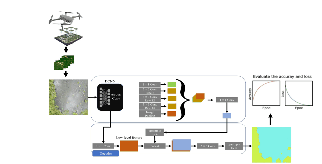
The dryness of peatlands is influenced by the density of vegetation. If peatlands are dry, they become vulnerable to a fire risk. To calculate the drought index, professionals must conduct a vegetation density analysis. However, field analysis requires vast amounts of resources. Moreover, the accuracy of the analysis based on satellite data is not adequate. Therefore, this research presents drone-captured two-dimensional image data. The object of this research is The Liang Anggang Protection Forest Block I in Banjarbaru, South Kalimantan, Indonesia. It is surveyed for information on its vegetation cover. Afterwards, There are 300 images of vegetation cover collected and utilized in total. The method of deep learning with semantic segmentation will be used to compare the results of determining methods with expert results as ground truth. The contribution of this study is to determine the optimal performance of deep learning model used for classifying vegetation density into three categories: bare/ungrazed, lightly grazed, and heavily grazed. Performance is evaluated based on correctness and intersection over union (IoU). Obtaining the proper parameters for the classification model using deep learning techniques and comparing the results of the best segmentation model are the objectives of the following contribution. From experimental studies conducted, the optimal momentum parameter value for MobileNetV2, Xception, and Inception-ResNet-v2 is 0.9, and the optimal accuracy performance is 82.69 percent on average. The most appropriate momentum for ResNet 18 architecture is 0.1. The result of semantic segmentation using the DeepLabV3 model with Inception-ResNet-v2 architecture is the optimal model for estimating vegetation density compared to U-Net model.
References
- Warren, M., Hergoualc’h, K., Kauffman, J. B., Murdiyarso, D., Kolka, R. (2017). An appraisal of Indonesia’s immense peat carbon stock using national peatland maps: uncertainties and potential losses from conversion. Carbon Balance and Management, 12 (1). doi: https://doi.org/10.1186/s13021-017-0080-2
- Gumbricht, T., Román-Cuesta, R. M., Verchot, L. V., Herold, M., Wittmann, F., Householder, E. et. al. (2017). Tropical and Subtropical Wetlands Distribution version 2. Center for International Forestry Research (CIFOR). doi: https://doi.org/10.17528/CIFOR/DATA.00058
- Margono, B. A., Potapov, P. V., Turubanova, S., Stolle, F., Hansen, M. C. (2014). Primary forest cover loss in Indonesia over 2000–2012. Nature Climate Change, 4 (8), 730–735. doi: https://doi.org/10.1038/nclimate2277
- Hope, G., Chokkalingam, U., Anwar, S. (2005). The Stratigraphy and Fire History of the Kutai Peatlands, Kalimantan, Indonesia. Quaternary Research, 64 (3), 407–417. doi: https://doi.org/10.1016/j.yqres.2005.08.009
- Tacconi, L. (2016). Preventing fires and haze in Southeast Asia. Nature Climate Change, 6 (7), 640–643. doi: https://doi.org/10.1038/nclimate3008
- Sandhyavitri, A., Amri, R., Fermana, D. (2016). Development of Underground Peat Fire Detection. Proceeding of the First International Conference on Technology, Innovation and Society. doi: https://doi.org/10.21063/ictis.2016.1069
- Garcia-Prats, A., Antonio, D. C., Tarcísio, F. J. G., Antonio, M. J. (2015). Development of a Keetch and Byram – Based drought index sensitive to forest management in Mediterranean conditions. Agricultural and Forest Meteorology, 205, 40–50. doi: https://doi.org/10.1016/j.agrformet.2015.02.009
- Keetch, J. J., Byram, G. M. (1988). Drought Index. Forest Seruice Research Paper, 36.
- Abalo, M., Badabate, D., Fousseni, F., Kpérkouma, W., Koffi, A. (2021). Landscape-based analysis of wetlands patterns in the Ogou River basin in Togo (West Africa). Environmental Challenges, 2, 100013. doi: https://doi.org/10.1016/j.envc.2020.100013
- Karlson, M., Gålfalk, M., Crill, P., Bousquet, P., Saunois, M., Bastviken, D. (2019). Delineating northern peatlands using Sentinel-1 time series and terrain indices from local and regional digital elevation models. Remote Sensing of Environment, 231, 111252. doi: https://doi.org/10.1016/j.rse.2019.111252
- Chughtai, A. H., Abbasi, H., Karas, I. R. (2021). A review on change detection method and accuracy assessment for land use land cover. Remote Sensing Applications: Society and Environment, 22, 100482. doi: https://doi.org/10.1016/j.rsase.2021.100482
- Meng, S., Wang, X., Hu, X., Luo, C., Zhong, Y. (2021). Deep learning-based crop mapping in the cloudy season using one-shot hyperspectral satellite imagery. Computers and Electronics in Agriculture, 186, 106188. doi: https://doi.org/10.1016/j.compag.2021.106188
- Campos-Taberner, M., García-Haro, F. J., Martínez, B., Izquierdo-Verdiguier, E., Atzberger, C., Camps-Valls, G., Gilabert, M. A. (2020). Understanding deep learning in land use classification based on Sentinel-2 time series. Scientific Reports, 10 (1). doi: https://doi.org/10.1038/s41598-020-74215-5
- Tan, J., Zuo, J., Xie, X., Ding, M., Xu, Z., Zhou, F. (2021). MLAs land cover mapping performance across varying geomorphology with Landsat OLI-8 and minimum human intervention. Ecological Informatics, 61, 101227. doi: https://doi.org/10.1016/j.ecoinf.2021.101227
- Zaldo-Aubanell, Q., Serra, I., Sardanyés, J., Alsedà, L., Maneja, R. (2021). Reviewing the reliability of Land Use and Land Cover data in studies relating human health to the environment. Environmental Research, 194, 110578. doi: https://doi.org/10.1016/j.envres.2020.110578
- Bunyangha, J., Majaliwa, Mwanjalolo. J. G., Muthumbi, Agnes. W., Gichuki, Nathan. N., Egeru, A. (2021). Past and future land use/land cover changes from multi-temporal Landsat imagery in Mpologoma catchment, eastern Uganda. The Egyptian Journal of Remote Sensing and Space Science, 24 (3), 675–685. doi: https://doi.org/10.1016/j.ejrs.2021.02.003
- Magnússon, R. Í., Limpens, J., Kleijn, D., van Huissteden, K., Maximov, T. C., Lobry, S., Heijmans, M. M. P. D. (2021). Shrub decline and expansion of wetland vegetation revealed by very high resolution land cover change detection in the Siberian lowland tundra. Science of The Total Environment, 782, 146877. doi: https://doi.org/10.1016/j.scitotenv.2021.146877
- Mao, D., Tian, Y., Wang, Z., Jia, M., Du, J., Song, C. (2021). Wetland changes in the Amur River Basin: Differing trends and proximate causes on the Chinese and Russian sides. Journal of Environmental Management, 280, 111670. doi: https://doi.org/10.1016/j.jenvman.2020.111670
- Su, H., Yao, W., Wu, Z., Zheng, P., Du, Q. (2021). Kernel low-rank representation with elastic net for China coastal wetland land cover classification using GF-5 hyperspectral imagery. ISPRS Journal of Photogrammetry and Remote Sensing, 171, 238–252. doi: https://doi.org/10.1016/j.isprsjprs.2020.11.018
- Khakim, M. Y. N., Bama, A. A., Yustian, I., Poerwono, P., Tsuji, T., Matsuoka, T. (2020). Peatland subsidence and vegetation cover degradation as impacts of the 2015 El niño event revealed by Sentinel-1A SAR data. International Journal of Applied Earth Observation and Geoinformation, 84, 101953. doi: https://doi.org/10.1016/j.jag.2019.101953
- Räsänen, A., Aurela, M., Juutinen, S., Kumpula, T., Lohila, A., Penttilä, T., Virtanen, T. (2019). Detecting northern peatland vegetation patterns at ultra‐high spatial resolution. Remote Sensing in Ecology and Conservation, 6 (4), 457–471. doi: https://doi.org/10.1002/rse2.140
- Lin, P., Lu, Q., Li, D., Chen, Y., Zou, Z., Jiang, S. (2019). Artificial intelligence classification of wetland vegetation morphology based on deep convolutional neural network. Natural Resource Modeling, 33 (1). doi: https://doi.org/10.1111/nrm.12248
- Huang, H., Lin, L., Tong, R., Hu, H., Zhang, Q., Iwamoto, Y. et. al. (2020). UNet 3+: A Full-Scale Connected UNet for Medical Image Segmentation. ICASSP 2020 – 2020 IEEE International Conference on Acoustics, Speech and Signal Processing (ICASSP), 1055–1059. doi: https://doi.org/10.1109/icassp40776.2020.9053405
- Chen, L.-C., Zhu, Y., Papandreou, G., Schroff, F., Adam, H. (2018). Encoder-Decoder with Atrous Separable Convolution for Semantic Image Segmentation. Lecture Notes in Computer Science, 833–851. doi: https://doi.org/10.1007/978-3-030-01234-2_49
- Szegedy, C., Ioffe, S., Vanhoucke, V., Alemi, A. (2017). Inception-v4, Inception-ResNet and the Impact of Residual Connections on Learning. Proceedings of the AAAI Conference on Artificial Intelligence, 31 (1), 4278–4284. doi: https://doi.org/10.1609/aaai.v31i1.11231
- Bianco, S., Cadene, R., Celona, L., Napoletano, P. (2018). Benchmark Analysis of Representative Deep Neural Network Architectures. IEEE Access, 6, 64270–64277. doi: https://doi.org/10.1109/access.2018.2877890
- Krizhevsky, A., Sutskever, I., Hinton, G. E. (2017). ImageNet classification with deep convolutional neural networks. Communications of the ACM, 60 (6), 84–90. doi: https://doi.org/10.1145/3065386
Downloads
Published
How to Cite
Issue
Section
License
Copyright (c) 2022 Yuslena Sari, Yudi Arifin, Novitasari Novitasari, Mohammad Faisal

This work is licensed under a Creative Commons Attribution 4.0 International License.
The consolidation and conditions for the transfer of copyright (identification of authorship) is carried out in the License Agreement. In particular, the authors reserve the right to the authorship of their manuscript and transfer the first publication of this work to the journal under the terms of the Creative Commons CC BY license. At the same time, they have the right to conclude on their own additional agreements concerning the non-exclusive distribution of the work in the form in which it was published by this journal, but provided that the link to the first publication of the article in this journal is preserved.
A license agreement is a document in which the author warrants that he/she owns all copyright for the work (manuscript, article, etc.).
The authors, signing the License Agreement with TECHNOLOGY CENTER PC, have all rights to the further use of their work, provided that they link to our edition in which the work was published.
According to the terms of the License Agreement, the Publisher TECHNOLOGY CENTER PC does not take away your copyrights and receives permission from the authors to use and dissemination of the publication through the world's scientific resources (own electronic resources, scientometric databases, repositories, libraries, etc.).
In the absence of a signed License Agreement or in the absence of this agreement of identifiers allowing to identify the identity of the author, the editors have no right to work with the manuscript.
It is important to remember that there is another type of agreement between authors and publishers – when copyright is transferred from the authors to the publisher. In this case, the authors lose ownership of their work and may not use it in any way.


