Development of a zero-shot classification method for cross-regional crop mapping demonstrating domain transferability in Sentinel-2 imagery
DOI:
https://doi.org/10.15587/1729-4061.2025.338000Keywords:
crop classification, domain transferability, remote sensing, machine learning, zero-shot classificationAbstract
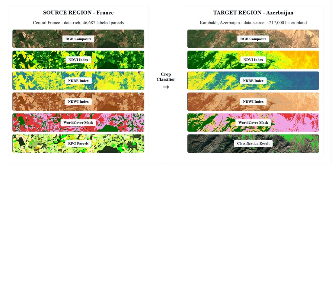
The object of the study is zero-shot crop-type classification in a data-poor target region (Karabakh, Azerbaijan) using a single-date Sentinel-2 composite, with the classifier trained on labeled parcels from a data-rich source region (central France). Cross-regional deployment of crop classifiers is impeded by domain shift differences in phenology, management, and sensor-band responses and by the absence of local labels, which together degrade accuracy and trust in operational maps. Cloud-free July-2021 median composites were produced in Google Earth Engine, a fourteen-band stack (core optical bands plus NDVI, NDRE, NDWI, NDMI) was assembled, four supervised algorithms were trained on balanced French parcels, validated using overall accuracy and Cohen’s κ, and then applied zero-shot to Karabakh. Random Forest yielded 94.6% accuracy on French validation and, after instance reweighting and feature normalization, delivered spatially coherent predictions in Karabakh. The pipeline’s combination of harmonized inputs, index-augmented spectra, and lightweight domain correction enabled transfer without target-region labels, generating confidence-aware maps suitable for rapid decision support. Growth-stage mismatch and spectral sensitivity are the main causes of performance differences, red-edge information was essential for distinguishing structurally similar crops, and moisture indices helped with irrigation-induced discrimination. The approach is most effective under peak-season, cloud-free conditions with comparable agro-ecological settings and a harmonized crop taxonomy, it requires only open Sentinel-2 data, a cropland mask, and standard ML tools in GEE, supporting scalable, repeatable assessments where ground truth is scarce
References
- Hoppe, H., Dietrich, P., Marzahn, P., Weiß, T., Nitzsche, C., Freiherr von Lukas, U. et al. (2024). Transferability of Machine Learning Models for Crop Classification in Remote Sensing Imagery Using a New Test Methodology: A Study on Phenological, Temporal, and Spatial Influences. Remote Sensing, 16 (9), 1493. https://doi.org/10.3390/rs16091493
- Rodriguez-Galiano, V. F., Ghimire, B., Rogan, J., Chica-Olmo, M., Rigol-Sanchez, J. P. (2012). An assessment of the effectiveness of a random forest classifier for land-cover classification. ISPRS Journal of Photogrammetry and Remote Sensing, 67, 93–104. https://doi.org/10.1016/j.isprsjprs.2011.11.002
- Saini, R., Ghosh, S. K. (2018). Crop classification on single date Sentinel-2 imagery using Random Forest and Support Vector Machine. The International Archives of the Photogrammetry, Remote Sensing and Spatial Information Sciences, XLII–5, 683–688. https://doi.org/10.5194/isprs-archives-xlii-5-683-2018
- Sonobe, R., Yamaya, Y., Tani, H., Wang, X., Kobayashi, N., Mochizuki, K. (2018). Crop classification from Sentinel-2-derived vegetation indices using ensemble learning. Journal of Applied Remote Sensing, 12 (2). https://doi.org/10.1117/1.jrs.12.026019
- Thanh Noi, P., Kappas, M. (2017). Comparison of Random Forest, k-Nearest Neighbor, and Support Vector Machine Classifiers for Land Cover Classification Using Sentinel-2 Imagery. Sensors, 18 (1), 18. https://doi.org/10.3390/s18010018
- Vuolo, F., Neuwirth, M., Immitzer, M., Atzberger, C., Ng, W.-T. (2018). How much does multi-temporal Sentinel-2 data improve crop type classification? International Journal of Applied Earth Observation and Geoinformation, 72, 122–130. https://doi.org/10.1016/j.jag.2018.06.007
- Pelletier, C., Valero, S., Inglada, J., Champion, N., Dedieu, G. (2016). Assessing the robustness of Random Forests to map land cover with high resolution satellite image time series over large areas. Remote Sensing of Environment, 187, 156–168. https://doi.org/10.1016/j.rse.2016.10.010
- Orynbaikyzy, A., Gessner, U., Conrad, C. (2022). Spatial Transferability of Random Forest Models for Crop Type Classification Using Sentinel-1 and Sentinel-2. Remote Sensing, 14 (6), 1493. https://doi.org/10.3390/rs14061493
- Gorelick, N., Hancher, M., Dixon, M., Ilyushchenko, S., Thau, D., Moore, R. (2017). Google Earth Engine: Planetary-scale geospatial analysis for everyone. Remote Sensing of Environment, 202, 18–27. https://doi.org/10.1016/j.rse.2017.06.031
- Zanaga, D., Van De Kerchove, R., Kirches, G., Daems, D., De Keersmaecker, W., Brockmann, C., Arino, O. (2022). ESA WorldCover 10 m 2021 v200: global land cover map. Zenodo. https://doi.org/10.5281/zenodo.7254221
- Attard, G., Bardonnet, J. (2020). RPG Version 2.0. Registre Parcellaire Graphique. Available at: https://geodatafr.github.io/IGN/RPG_Agricultural-parcels/
- Pettorelli, N., Vik, J. O., Mysterud, A., Gaillard, J.-M., Tucker, C. J., Stenseth, N. Chr. (2005). Using the satellite-derived NDVI to assess ecological responses to environmental change. Trends in Ecology & Evolution, 20 (9), 503–510. https://doi.org/10.1016/j.tree.2005.05.011
- Gitelson, A. A., Merzlyak, M. N. (1997). Remote estimation of chlorophyll content in higher plant leaves. International Journal of Remote Sensing, 18 (12), 2691–2697. https://doi.org/10.1080/014311697217558
- McFeeters, S. K. (1996). The use of the Normalized Difference Water Index (NDWI) in the delineation of open water features. International Journal of Remote Sensing, 17 (7), 1425–1432. https://doi.org/10.1080/01431169608948714
- Gao, B. (1996). NDWI–A normalized difference water index for remote sensing of vegetation liquid water from space. Remote Sensing of Environment, 58 (3), 257–266. https://doi.org/10.1016/s0034-4257(96)00067-3
Downloads
Published
How to Cite
Issue
Section
License
Copyright (c) 2025 Artughrul Gayibov

This work is licensed under a Creative Commons Attribution 4.0 International License.
The consolidation and conditions for the transfer of copyright (identification of authorship) is carried out in the License Agreement. In particular, the authors reserve the right to the authorship of their manuscript and transfer the first publication of this work to the journal under the terms of the Creative Commons CC BY license. At the same time, they have the right to conclude on their own additional agreements concerning the non-exclusive distribution of the work in the form in which it was published by this journal, but provided that the link to the first publication of the article in this journal is preserved.
A license agreement is a document in which the author warrants that he/she owns all copyright for the work (manuscript, article, etc.).
The authors, signing the License Agreement with TECHNOLOGY CENTER PC, have all rights to the further use of their work, provided that they link to our edition in which the work was published.
According to the terms of the License Agreement, the Publisher TECHNOLOGY CENTER PC does not take away your copyrights and receives permission from the authors to use and dissemination of the publication through the world's scientific resources (own electronic resources, scientometric databases, repositories, libraries, etc.).
In the absence of a signed License Agreement or in the absence of this agreement of identifiers allowing to identify the identity of the author, the editors have no right to work with the manuscript.
It is important to remember that there is another type of agreement between authors and publishers – when copyright is transferred from the authors to the publisher. In this case, the authors lose ownership of their work and may not use it in any way.