Improving a method that rapidly determines the phantomization areas in an image acquired from a space-based radar observation system
DOI:
https://doi.org/10.15587/1729-4061.2025.347659Keywords:
space radar surveillance system, phantom area, errors of the first and second kindAbstract
This work examines the process that determines a phantom area in an image acquired from a space radar observation system. The principal hypothesis of the study assumed that improving a method for defining the phantom area could reduce image processing errors of the first and second kind.
The operational method for determining the phantom area in an image acquired from a space radar observation system has been improved; in it, in contrast to known ones,
– a radar image is represented as a two-dimensional array of pixels whose intensity is determined by the amplitude of the radar signal in grayscale;
– the influence of speckle noise is minimized using convolution with a Gaussian filter;
– the image histogram is aligned to increase contrast;
– the boundaries in the image are selected using a gradient operator;
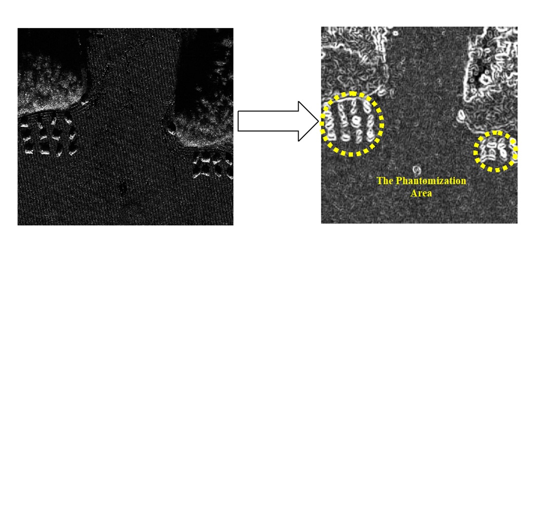
– the area with the selected boundaries with objects of interest is defined as the phantom area in the image acquired from a space radar observation system.
An experimental study was conducted on the operational determination of the phantom area in an image from a space radar surveillance system. Phantom areas on which objects of interest are located are highlighted in an image from a space radar surveillance system. At the final stage of the improved method for boundary selection, the Sobel, Prewitt, and Roberts operators are considered. The choice of the Roberts operator at the final stage for boundary selection allowed for the following:
– a decrease in processing errors of the first kind: by 2.64% compared to the Sobel operator; by 5.66% compared to the Prewitt operator;
– a reduction of processing errors of the second kind: by 2.4% compared to the Sobel operator; by 4.26% compared to the Prewitt operator
References
- Amitrano, D., Di Martino, G., Di Simone, A., Imperatore, P. (2024). Flood Detection with SAR: A Review of Techniques and Datasets. Remote Sensing, 16 (4), 656. https://doi.org/10.3390/rs16040656
- Pavlikov, V., Zhyla, S., Pozdniakov, P., Kolesnikov, D., Cherepnin, H., Shmatko, O. et al. (2024). Foundations of radar synthesis theory of phantom objects formation in SAR images. Radioelectronic and Computer Systems, 2024 (4), 123–140. https://doi.org/10.32620/reks.2024.4.11
- Hrushko, O., Zhytar, D., Ilkiv, E., Hrynishak, M., Kukhtar, D. (2025). Geospatial Analysis of War-Affected Areas in Ukraine Based on SAR and GIS Technologies. 18th International Conference Monitoring of Geological Processes and Ecological Condition of the Environment, 1–5. https://doi.org/10.3997/2214-4609.2025510159
- Al-Bayati, M., El-Zaart, A. (2013). Automatic Thresholding Techniques for SAR Images. Computer Science & Information Technology (CS & IT), 75–84. https://doi.org/10.5121/csit.2013.3308
- Tan, J., Tang, Y., Liu, B., Zhao, G., Mu, Y., Sun, M., Wang, B. (2023). A Self-Adaptive Thresholding Approach for Automatic Water Extraction Using Sentinel-1 SAR Imagery Based on OTSU Algorithm and Distance Block. Remote Sensing, 15 (10), 2690. https://doi.org/10.3390/rs15102690
- Hillebrand, F. L., Prieto, J. D., Mendes Júnior, C. W., Arigony-Neto, J., Simões, J. C. (2024). Gray Level Co-occurrence Matrix textural analysis for temporal mapping of sea ice in Sentinel-1A SAR images. Anais Da Academia Brasileira de Ciências, 96 (2). https://doi.org/10.1590/0001-3765202420240554
- Anusha, N., Vasanth, K., Masurkar, S. P. (2024). Automated Extraction of Textural Features From Segmented Sentinel-1ASynthetic Aperture Radar Satellite Image Using Grey Level Co-Occurrence Matrix. Procedia Computer Science, 235, 2124–2134. https://doi.org/10.1016/j.procs.2024.04.201
- Zhai, Y., Liu, K., Piuri, V., Ying, Z., Xu, Y. (2016). SAR automatic target recognition based on K-means and data augmentation. Proceedings of the 2016 International Conference on Intelligent Information Processing, 1–6. https://doi.org/10.1145/3028842.3028894
- Chen, Z., Cong, B., Hua, Z., Cengiz, K., Shabaz, M. (2021). Application of clustering algorithm in complex landscape farmland synthetic aperture radar image segmentation. Journal of Intelligent Systems, 30 (1), 1014–1025. https://doi.org/10.1515/jisys-2021-0096
- Qin, J., Liu, Z., Ran, L., Xie, R., Tang, J., Zhu, H. (2023). An SAR Image Automatic Target Recognition Method Based on the Scattering Parameter Gaussian Mixture Model. Remote Sensing, 15 (15), 3800. https://doi.org/10.3390/rs15153800
- Ma, F., Gao, F., Sun, J., Zhou, H., Hussain, A. (2019). Weakly Supervised Segmentation of SAR Imagery Using Superpixel and Hierarchically Adversarial CRF. Remote Sensing, 11 (5), 512. https://doi.org/10.3390/rs11050512
- Yin, J., Liu, X., Yang, J., Chu, C.-Y., Chang, Y.-L. (2020). PolSAR Image Classification Based on Statistical Distribution and MRF. Remote Sensing, 12 (6), 1027. https://doi.org/10.3390/rs12061027
- Hu, G. C., Zhao, Q. H. (2017). G0-WISHART distribution based classification from polarimetric sar images. ISPRS Annals of the Photogrammetry, Remote Sensing and Spatial Information Sciences, IV-2/W4, 451–455. https://doi.org/10.5194/isprs-annals-iv-2-w4-451-2017
- Carvalho, E. A., Ushizima, D. M., Medeiros, F. N. S., Martins, C. I. O., Marques, R. C. P., Oliveira, I. N. S. (2010). SAR imagery segmentation by statistical region growing and hierarchical merging. Digital Signal Processing, 20 (5), 1365–1378. https://doi.org/10.1016/j.dsp.2009.10.014
- Guo, Z., Wu, L., Huang, Y., Guo, Z., Zhao, J., Li, N. (2022). Water-Body Segmentation for SAR Images: Past, Current, and Future. Remote Sensing, 14 (7), 1752. https://doi.org/10.3390/rs14071752
- Bao, L., Lv, X., Yao, J. (2021). Water Extraction in SAR Images Using Features Analysis and Dual-Threshold Graph Cut Model. Remote Sensing, 13 (17), 3465. https://doi.org/10.3390/rs13173465
- Li, M., Zou, H., Qin, X., Dong, Z., Sun, L., Wei, J. (2023). Superpixel Generation for Polarimetric SAR Images with Adaptive Size Estimation and Determinant Ratio Test Distance. Remote Sensing, 15 (4), 1123. https://doi.org/10.3390/rs15041123
- Li, K., Zhang, M., Xu, M., Tang, R., Wang, L., Wang, H. (2022). Ship Detection in SAR Images Based on Feature Enhancement Swin Transformer and Adjacent Feature Fusion. Remote Sensing, 14 (13), 3186. https://doi.org/10.3390/rs14133186
- Zhao, K., Lu, R., Wang, S., Yang, X., Li, Q., Fan, J. (2023). ST-YOLOA: a Swin-transformer-based YOLO model with an attention mechanism for SAR ship detection under complex background. Frontiers in Neurorobotics, 17. https://doi.org/10.3389/fnbot.2023.1170163
- Dewi, N. P. K., Suputra, P. H., Paramartha, A. A. G. Y., Dewi, L. J. E., Varnakovida, P., Aryanto, K. Y. E. (2025). River Area Segmentation Using Sentinel-1 SAR Imagery with Deep-Learning Approach. Geomatics and Environmental Engineering, 19 (4), 39–63. https://doi.org/10.7494/geom.2025.19.4.39
- Ruban, I., Makoveichuk, O., Khudov, V., Khudov, H., Khizhnyak, I., Yuzova, I., Drob, Y. (2019). The Method for Selecting the Urban Infrastructure Objects Contours. 2019 IEEE International Scientific-Practical Conference Problems of Infocommunications, Science and Technology (PIC S&T), 689–693. https://doi.org/10.1109/picst47496.2019.9061267
- Ruban, I., Khudov, H., Makoveichuk, O., Khudov, V., Kalimulin, T., Glukhov, S. et al. (2022). Methods of UAVs images segmentation based on k-means and a genetic algorithm. Eastern-European Journal of Enterprise Technologies, 4 (9 (118)), 30–40. https://doi.org/10.15587/1729-4061.2022.263387
- Khudov, H., Makoveichuk, O., Khizhnyak, I., Shamrai, B., Glukhov, S., Lunov, O. et al. (2022). The Method for Determining Informative Zones on Images from On-Board Surveillance Systems. International Journal of Emerging Technology and Advanced Engineering, 12 (8), 61–69. https://doi.org/10.46338/ijetae0822_08
- Khudov, H., Khudov, R., Khizhnyak, I., Hridasov, I., Hlushchenko, P. (2025). The small aerial objects segmentation method on optical-electronic images based on the sobel edge detector. Advanced Information Systems, 9 (2), 5–10. https://doi.org/10.20998/2522-9052.2025.2.01
- Rafael, C., Gonzalez, R. E. W. (2002). Digital Image Processing. Prentice Hall, 793. Available at: https://www.amazon.com/Digital-Image-Processing-Rafael-Gonzalez/dp/0201180758
- Sentinel-1. Available at: https://sentinels.copernicus.eu/copernicus/sentinel-1
Downloads
Published
How to Cite
Issue
Section
License
Copyright (c) 2025 Hennadii Khudov, Oleksandr Makoveichuk, Irina Khizhnyak, Dmytro Huriev, Anatoliy Popov, Serhii Oliynick, Pavlo Malashta, Yaroslav Sydorov, Оlexandr Rohulia, Maksym Adamchuk

This work is licensed under a Creative Commons Attribution 4.0 International License.
The consolidation and conditions for the transfer of copyright (identification of authorship) is carried out in the License Agreement. In particular, the authors reserve the right to the authorship of their manuscript and transfer the first publication of this work to the journal under the terms of the Creative Commons CC BY license. At the same time, they have the right to conclude on their own additional agreements concerning the non-exclusive distribution of the work in the form in which it was published by this journal, but provided that the link to the first publication of the article in this journal is preserved.
A license agreement is a document in which the author warrants that he/she owns all copyright for the work (manuscript, article, etc.).
The authors, signing the License Agreement with TECHNOLOGY CENTER PC, have all rights to the further use of their work, provided that they link to our edition in which the work was published.
According to the terms of the License Agreement, the Publisher TECHNOLOGY CENTER PC does not take away your copyrights and receives permission from the authors to use and dissemination of the publication through the world's scientific resources (own electronic resources, scientometric databases, repositories, libraries, etc.).
In the absence of a signed License Agreement or in the absence of this agreement of identifiers allowing to identify the identity of the author, the editors have no right to work with the manuscript.
It is important to remember that there is another type of agreement between authors and publishers – when copyright is transferred from the authors to the publisher. In this case, the authors lose ownership of their work and may not use it in any way.