Improving the operational efficiency of control centers for emergency events by using GIS technologies
DOI:
https://doi.org/10.15587/1729-4061.2023.285938Keywords:
crisis center, control centers, emergency event, geoinformation systems, MARPLOT, CAMEO, ALOHA, evacuationAbstract
The object of the study is the functioning of control centers during emergencies.
Ukraine has faced large-scale emergency events caused by Russian aggression. The experience of crisis management in emergency events showed the need to find new solutions and improve the activities of emergency management centers at the State Emergency Service of Ukraine and GIS technologies in decision-making support systems.
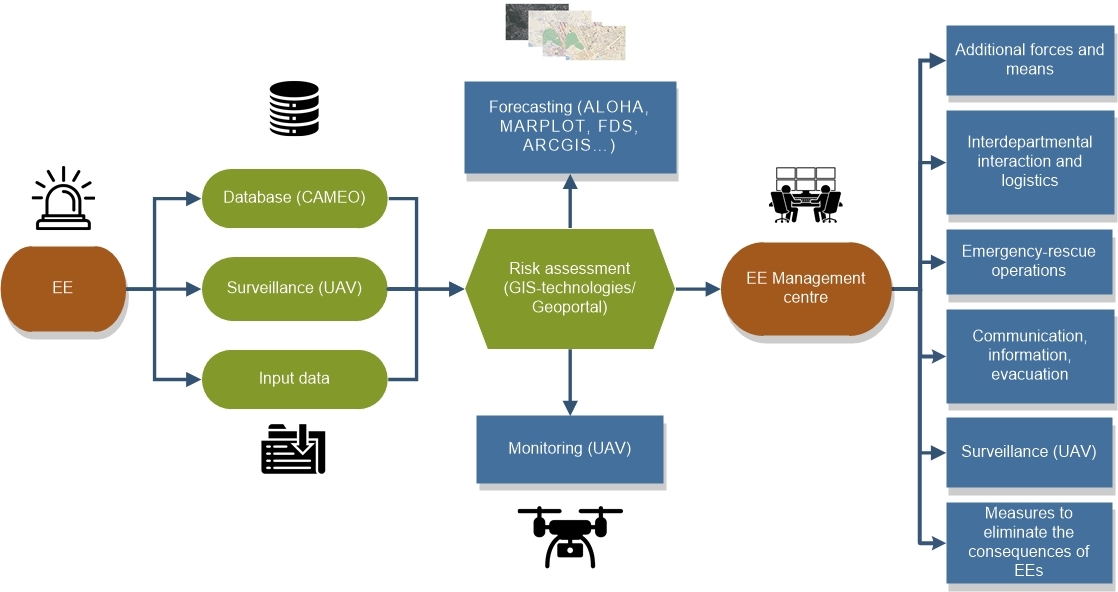
The curent paper has formulated a conceptual model of the work of emergency management centers at the Emergency Service of Ukraine; based on it, their main functions were formed. Identification of risks for objects that carry potential danger was carried out and a block diagram of object risk assessment was developed to improve the work of emergency control centers at the State Emergency Service of Ukraine. An approximate list of software and online resources for the operation of emergency management centers at Emergency Service of Ukraine is provided, which makes it possible to summarize the risks that are present in the given territory, isolate them, and pay special attention to prevent possible consequences from them.
Based on the computer software MARPLOT, CAMEO, and ALOHA, an example of response to an emergency event was described. In this case, the weather conditions, physico-chemical parameters of the dangerous substance, and the radii of the danger zones of its distribution and the number of people who need to be evacuated were taken into account. In practice, having this knowledge, a head of the emergency management center at the State Emergency Service of Ukraine will be able to effectively manage people without exposing them to danger, as well as conduct timely evacuation. The use of these programs makes it possible to reduce the time of hazard assessment and visualize them, which creates advantages over the existing methodology of the State Emergency Service of Ukraine in terms of speed of hazard assessment.
The results have made it possible to solve the problem of increasing the efficiency of the emergency management centers at the Emergency Service of Ukraine and to create the prerequisites for building a geo-information portal that could combine various methods and techniques on one platform
References
- Yemelyanenko, S., Rudyk, Y., Kuzyk, A., Yakovchuk, R. (2018). Geoinformational system of rescue services. MATEC Web of Conferences, 247, 00030. doi: https://doi.org/10.1051/matecconf/201824700030
- Yemelyanenko, S., Rudyk, Y., Ivanusa, A. (2018). Geoinformational System for Risk Assessment Visualization. 2018 IEEE 13th International Scientific and Technical Conference on Computer Sciences and Information Technologies (CSIT). doi: https://doi.org/10.1109/stc-csit.2018.8526743
- Emergency Response Coordination Centre (ERCC). Available at: https://civil-protection-humanitarian-aid.ec.europa.eu/what/civil-protection/emergency-response-coordination-centre-ercc_en
- Horita, F. E. A., de Albuquerque, J. P., Marchezini, V. (2018). Understanding the decision-making process in disaster risk monitoring and early-warning: A case study within a control room in Brazil. International Journal of Disaster Risk Reduction, 28, 22–31. doi: https://doi.org/10.1016/j.ijdrr.2018.01.034
- Zhyvylo, Y. О. (2022). Situation Center of the Ministry of Defense of Ukraine – a model of early detection and analysis of crisis situations in the state security sector. Pressing Problems of Public Administration, 1 (60), 27–41. Available at: https://periodicals.karazin.ua/apdu/article/view/21125
- Ustymenko, O. V. (2018). Situational centres of state bodies as a reserve system for bringing the units and parts of the defence forces to higher levels of combat readiness. Naukovyi chasopys Akademii natsionalnoi bezpeky, 2, 136–148. Available at: http://nbuv.gov.ua/UJRN/nivanb_2018_2_11
- Druzhynin, S. V., Klymovych, O. K. (2017). Vyznachennia faktoriv ta parametriv protsesu funktsionuvannia informatsiino-telekomunikatsiynoi merezhi Zbroinykh Syl Ukrainy. Zbirnyk naukovykh prats Viyskovoi akademiyi (m. Odesa). Tekhnichni nauky, 2, 171–177.
- European Civil Protection Pool. Available at: https://civil-protection-humanitarian-aid.ec.europa.eu/what/civil-protection/european-civil-protection-pool_en
- Dokument zawiera zgodny z nomenklaturą normy ISO Guide 73:2009 wykaz informacji o zidentyfikowanych ryzykach oraz szeroki opis potencjalnych ryzyk, wraz z opisem działań państwa zmierzających do ich ograniczenia. Głównie stanowi jednak podstawę do planowania dla podmiotów i jednostek administracji publicznej.
- W normie ISO proces ten obejmuje identyfikację, analizę oraz ewaluację ryzyka, natomiast w dokumencie brytyjskim zawiera: identyfikację ryzyka, ocenę prawdopodobieństwa ryzyk i ich konsekwencji oraz porównanie ryzyk.
- Iannella, R., Henricksen, K. (2007). Managing information in the disaster coordination centre: Lessons and opportunities. Proceedings of the 4th International ISCRAM Conference. Available at: https://citeseerx.ist.psu.edu/document?repid=rep1&type=pdf&doi=a4e049f81a397b152883c409092d31ce43c6d435
- Boisvert, P., Moore, R. (2003). Crisis and Emergency Management: a guide for manager of the Public Service of Canada. Ottawa - Ontario: Canadian Centre for Management Development. Available at: https://publications.gc.ca/site/eng/9.686713/publication.html
- Militello, L. G., Patterson, E. S., Wears, R., Ritter, J. A. (2005). Large-Scale Coordination in Emergency Response. Proceedings of the Human Factors and Ergonomics Society Annual Meeting, 49 (3), 534–538. doi: https://doi.org/10.1177/154193120504900368
- Hashemipour, M., Stuban, S. M., Dever, J. R. (2017). A community-based disaster coordination framework for effective disaster preparedness and response. Australian Journal of Emergency Management, 32 (2), 41–46. Available at: https://knowledge.aidr.org.au/media/3658/ajem-32-02-18.pdf
- Nakaz MVS Ukrainy «Pro zatverdzhennia Metodyky prohnozuvannia naslidkiv vylyvu (vykydu) nebezpechnykh khimichnykh rechovyn pid chas avariy na khimichno nebezpechnykh obiektakh i transporti» vid 29.11.2019 No. 1000. Available at: https://zakon.rada.gov.ua/laws/show/z0440-20#Text
- Yung, D. (2008). Principles of Fire Risk Assessment in Buildings. John Wiley & Sons. doi: https://doi.org/10.1002/9780470714065
- MARPLOT Software. Available at: https://www.iafc.org/topics-and-tools/resources/resource/marplot-software
- What is the CAMEO software suite? Available at: https://19january2017snapshot.epa.gov/cameo/what-cameo-software-suite_.html
- ALOHA Software. Available at: https://www.epa.gov/cameo/aloha-software
- Ukrainskyi hidrometeorolohichnyi tsentr. Available at: https://www.meteo.gov.ua/
- Vprovadzhennia Dyrektyvy 2007/60/YeS Yevropeiskoho Parlamentu ta Rady vid 23 zhovtnia 2007 roku pro otsinku ta upravlinnia ryzykamy zatoplennia. Derzhavna sluzhba Ukrainy z nadzvychainykh sytuatsiy. Available at: https://dsns.gov.ua/poperedzhennya-pro-ymovirni-nadzvichayni-situaciyi-abo-uskladnennya/vprovadghennya-directiva-2007-60-ec-of-the-european-parliament-and-of-the-council-of-23-october-2007-on-the-assessment-and-management-of-flood-risks#mcetoc_1gtaq1udh3b
- The OpenGTS Project. Available at: http://www.opengts.org/
- McGrattan, K. B., Klein, B., Hostikka, S., Floyd, J. E. (2007). Fire Dynamics Simulator (Version 5) User’s Guide. NIST Special Publication 1019-5. doi: https://doi.org/10.6028/nist.sp.1019-5
- ArcGIS Online. Available at: https://www.arcgis.com/index.html
- Yemelyanenko, S., Ivanusa, A., Klym, H. (2017). Mechanism of fire risk management in projects of safe operation of place for assemblage of people. 2017 12th International Scientific and Technical Conference on Computer Sciences and Information Technologies (CSIT). doi: https://doi.org/10.1109/stc-csit.2017.8098792
- Hulida, E., Pasnak, I., Koval, O., Tryhuba, A. (2019). Determination of the Critical Time of Fire in the Building and Ensure Successful Evacuation of People. Periodica Polytechnica Civil Engineering. doi: https://doi.org/10.3311/ppci.12760
Downloads
Published
How to Cite
Issue
Section
License
Copyright (c) 2023 Sergiy Yemelyanenko, Andriy Kuzyk, Andriy Ivanusa, Danyil Behen, Roman Koval, Yevhen Morshch

This work is licensed under a Creative Commons Attribution 4.0 International License.
The consolidation and conditions for the transfer of copyright (identification of authorship) is carried out in the License Agreement. In particular, the authors reserve the right to the authorship of their manuscript and transfer the first publication of this work to the journal under the terms of the Creative Commons CC BY license. At the same time, they have the right to conclude on their own additional agreements concerning the non-exclusive distribution of the work in the form in which it was published by this journal, but provided that the link to the first publication of the article in this journal is preserved.
A license agreement is a document in which the author warrants that he/she owns all copyright for the work (manuscript, article, etc.).
The authors, signing the License Agreement with TECHNOLOGY CENTER PC, have all rights to the further use of their work, provided that they link to our edition in which the work was published.
According to the terms of the License Agreement, the Publisher TECHNOLOGY CENTER PC does not take away your copyrights and receives permission from the authors to use and dissemination of the publication through the world's scientific resources (own electronic resources, scientometric databases, repositories, libraries, etc.).
In the absence of a signed License Agreement or in the absence of this agreement of identifiers allowing to identify the identity of the author, the editors have no right to work with the manuscript.
It is important to remember that there is another type of agreement between authors and publishers – when copyright is transferred from the authors to the publisher. In this case, the authors lose ownership of their work and may not use it in any way.