Devising a procedure for integrated modeling of riverbed shape in the area of bridge crossing in order to avoid dangerous washing erosion
DOI:
https://doi.org/10.15587/1729-4061.2024.298675Keywords:
riverbed, bridge crossing, flood, hydromorphodynamics of riverbed flows, canalized riverbed, Google Earth systemsAbstract
The object of research is a riverbed in the area of a bridge crossing, which is subject to the action of high water during the passage of a flood.
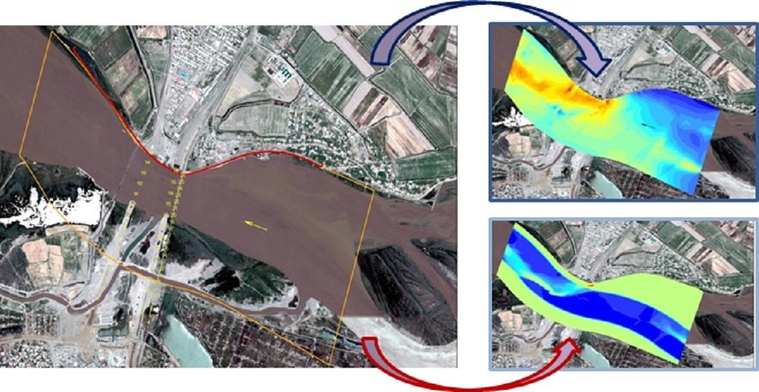
The selection of parameters and contours of the scheme of the river section was carried out using a mathematical model of the flow and deformation of the bed of the riverbed before and after the change of its shape. It was established that the assignment of parameters of the operational slot should be performed on the basis of the principle of creating natural analogs of riverbed shapes, riverbed and floodplain terraces, with the use of mathematical modeling.
To reduce erosion in the area of bridge crossings, it is proposed to regulate the riverbed by constructing a canalized riverbed. Modeling according to this option showed that the erosion in the span of a road bridge decreased and did not exceed 1.5 m. In addition, it was established that a significant role in ensuring the stability of the river is played by the vegetation cover in floodplain areas.
Using the method of mathematical modeling, it was established that the area near the convex bank with a width of 150 m is subject to the strongest erosion in the design of the supports. Siltation of the existing left-bank bottom basin is also observed.
It is recommended to make a decision to carry out restorative cutting of riverbed alignment annually after receiving a flood forecast from the local hydrometeorological station. In the case of a high flood warning, work should be carried out to clear the sleeves on the approach to the construction of the bridge deck.
It was established that the most stable shape of riverbeds is in the form of curvilinear incomplete meandering when the radii of curvature R and the width of the riverbed B satisfy the ratio R=(4...7) B at riverbed-forming flow rate. At the same time, radii of curvature R<3.5 B should not be allowed, as this leads to separation of the flow from the convex bank and excessive erosion of the concave bank
References
- Ostroverkh, B. M., Potapenko, L. S. (2007). Vyrishennia problem rozrakhunku ta proektuvannia richkovykh ta pryberezhnykh sporud z vykorystanniam metodiv HIS. K.: Suchasni problemy stvorennia i efektyvnoho vykorystannia yedynoho heoinformatsiynoho prostoru Ukrainy pry pidhotovtsi i pryiniatti upravlinskykh rishen, 1–6.
- Nishchuk, V. S. (Ed.) (2000). Inzhenernyi zakhyst ta osvoiennia terytoriy. Kyiv: «Osnova», 358.
- Ostroverkh, B. N., Khomytskyi, V. V. (2007). Rozvytok teoriyi i metodiv modeliuvannia ruslovykh protsesiv v Instytuti hidromekhaniky NAN Ukrainy. Prykladna hidromekhanika, 9 (2-3), 139–149. Available at: http://dspace.nbuv.gov.ua/handle/123456789/4706
- Bever, A. J., MacWilliams, M. L. (2013). Simulating sediment transport processes in San Pablo Bay using coupled hydrodynamic, wave, and sediment transport models. Marine Geology, 345, 235–253. https://doi.org/10.1016/j.margeo.2013.06.012
- Kim, B. (2014). Resilience Assessment of Dams’ Flood-Control Service. Journal of the Korean Society of Civil Engineers, 34 (6), 1919. https://doi.org/10.12652/ksce.2014.34.6.1919
- Two dimensional Depth-averaged Flow and Sediment Transport Model (2003). Publication No. FHWA-RD-03-053. U.S. Department of Transportation.
- Onyshchenko, A., Ostroverkh, B., Potapenko, L., Kovalchuk, V., Tokin, O., Harkusha, M. et al. (2022). Devising a procedure to calculate and analyze parameters for passing the flood and breakthrough wave taking into consideration the topographical and hydraulic riverbed irregularities. Eastern-European Journal of Enterprise Technologies, 1 (10 (115)), 6–16. https://doi.org/10.15587/1729-4061.2022.252710
- Slavinska, O., Tsynka, А., Bashkevych, I. (2020). Predicting deformations in the area of impact exerted by a bridge crossing based on the proposed mathematical model of a floodplain flow. Eastern-European Journal of Enterprise Technologies, 4 (7 (106)), 75–87. https://doi.org/10.15587/1729-4061.2020.208634
- Zhaparkulova, Y., Nabiollina, M., Amanbayeva, B. (2019). Methods of forecasting calculations of breakthrough wave at hydrodynamic accidents waterstorage dam. E3S Web of Conferences, 97, 05033. https://doi.org/10.1051/e3sconf/20199705033
- Veremenyuk, V. V., Ivashechkin, V. V., Nemerovets, O. V. (2019). Modeling of Process for Level Changes in Cascade of Two Channel Water Reservoirs in Case of Flooding. Science & Technique, 18 (2), 146–154. https://doi.org/10.21122/2227-1031-2019-18-2-146-154
- Morales, R., Ettema, R. (2013). Insights from Depth-Averaged Numerical Simulation of Flow at Bridge Abutments in Compound Channels. Journal of Hydraulic Engineering, 139 (5), 470–481. https://doi.org/10.1061/(asce)hy.1943-7900.0000693
Downloads
Published
How to Cite
Issue
Section
License
Copyright (c) 2024 Artur Onyshchenko, Вorys Ostroverkh, Liudmyla Potapenko, Vitalii Kovalchuk, Oleksandr Zdolnyk, Andriy Pentsak

This work is licensed under a Creative Commons Attribution 4.0 International License.
The consolidation and conditions for the transfer of copyright (identification of authorship) is carried out in the License Agreement. In particular, the authors reserve the right to the authorship of their manuscript and transfer the first publication of this work to the journal under the terms of the Creative Commons CC BY license. At the same time, they have the right to conclude on their own additional agreements concerning the non-exclusive distribution of the work in the form in which it was published by this journal, but provided that the link to the first publication of the article in this journal is preserved.
A license agreement is a document in which the author warrants that he/she owns all copyright for the work (manuscript, article, etc.).
The authors, signing the License Agreement with TECHNOLOGY CENTER PC, have all rights to the further use of their work, provided that they link to our edition in which the work was published.
According to the terms of the License Agreement, the Publisher TECHNOLOGY CENTER PC does not take away your copyrights and receives permission from the authors to use and dissemination of the publication through the world's scientific resources (own electronic resources, scientometric databases, repositories, libraries, etc.).
In the absence of a signed License Agreement or in the absence of this agreement of identifiers allowing to identify the identity of the author, the editors have no right to work with the manuscript.
It is important to remember that there is another type of agreement between authors and publishers – when copyright is transferred from the authors to the publisher. In this case, the authors lose ownership of their work and may not use it in any way.