Devising a method for determining the coordinates of an unmanned aerial vehicle by a network of three software-defined-radio receivers used in pairs
DOI:
https://doi.org/10.15587/1729-4061.2025.326781Keywords:
unmanned aerial vehicle, paired use of SDR receivers, bearing intersection angleAbstract
The object of this study is the process of determining the coordinates of an unmanned aerial vehicle. The main hypothesis of the study assumed that the use of a network of three Software-Defined Radio (SDR) receivers could improve the accuracy of determining the coordinates of an unmanned aerial vehicle. The use of SDR receivers in pairs would reduce the number of false bearings.
A method for determining the coordinates of an unmanned aerial vehicle by a network of three SDR receivers when used in pairs has been improved, which, unlike the known ones, involves:
– measuring bearings by each SDR receiver;
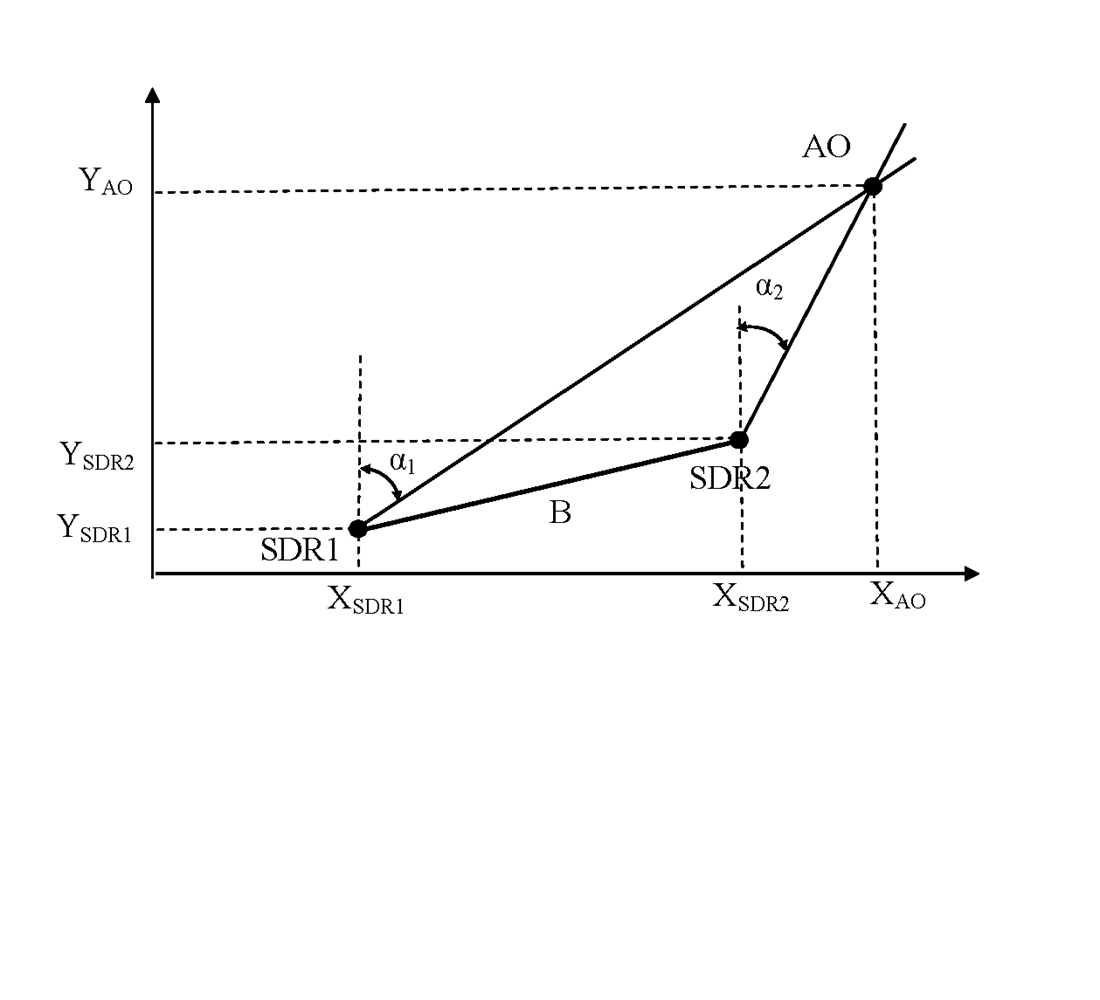
– determining the pairwise angles of intersection of bearings;
– determining the maximum of the pairwise angles of intersection;
– determining a pair of SDR receivers for further calculations;
– using the triangulation method for determining the coordinates of an unmanned aerial vehicle.
The accuracy of determining the coordinates of an aerial object by a network of two SDR receivers has been assessed. It was found that:
– the shape, orientation, and size of the error ellipses depend on the relative location in space of the SDR receivers and the unmanned aerial vehicle;
– the size of the scattering ellipses is reduced by (20–40) % due to the use of information from the optimal pair;
– in some cases, false switching of SDR receiver pairs is noticeable;
– the pair (first SDR receiver – third SDR receiver) has the largest base from the considered options, that is, starting from a certain range, the angle of intersection of the bearings for this case is closest to 90°, the area of the scattering ellipses of coordinate measurement errors is minimal, which determines its choice;
– when moving the unmanned aerial vehicle beyond the network coverage area of the SDR receiver pair, it is advisable to use another pair, this involves the use of a “chain” of SDR receivers
References
- Goldstein, L., Waechter, N. (2023). Chinese Strategists Evaluate the Use of 'Kamikaze' Drones in the Russia-Ukraine War. Available at: https://www.rand.org/pubs/commentary/2023/11/chinese-strategists-evaluate-the-use-of-kamikaze-drones.html
- Grigore, L., Cristescu, C. (2024). The Use of Drones in Tactical Military Operations in the Integrated and Cybernetic Battlefield. Land Forces Academy Review, 29 (2), 269–273. https://doi.org/10.2478/raft-2024-0029
- Riabukha, V. P. (2020). Radar Surveillance of Unmanned Aerial Vehicles (Review). Radioelectronics and Communications Systems, 63 (11), 561–573. https://doi.org/10.3103/s0735272720110011
- Hrudka, O. (2024). Russian drone manufacturer ‘Orlan-10’ ramps up production despite sanctions, Inform Napalm reports. Available at: https://euromaidanpress.com/2024/01/13/russian-drone-manufacturer-orlan-10-ramps-up-production-despite-sanctions-inform-napalm-reports/
- British intelligence: Russian radar destroyed in missile attack on Belbek in Crimea (2024). Available at: https://mind.ua/en/news/20269399-british-intelligence-russian-radar-destroyed-in-missile-attack-on-belbek-in-crimea
- Khudov, H., Makoveichuk, O., Kostyria, O., Butko, I., Poliakov, A., Kozhushko, Y. et al. (2024). Devising a method for determining the coordinates of an unmanned aerial vechicle via a network of portable spectrum analyzers. Eastern-European Journal of Enterprise Technologies, 6 (9 (132)), 97–107. https://doi.org/10.15587/1729-4061.2024.318551
- Khudov, H., Kostianets, O., Kovalenko, O., Maslenko, O., Solomonenko, Y. (2023). Using Software-Defined radio receivers for determining the coordinates of low-visible aerial objects. Eastern-European Journal of Enterprise Technologies, 4 (9 (124)), 61–73. https://doi.org/10.15587/1729-4061.2023.286466
- Boussel, P. (2024). The Golden Age of Drones: Military UAV Strategic Issues and Tactical Developments. Available at: https://trendsresearch.org/insight/the-golden-age-of-drones-military-uav-strategic-issues-and-tactical-developments/?srsltid=AfmBOoptC41niCzbAJGHOTcUhRGJpWEW_y7hHLkJ_5hkabW_fIBS5sZ
- Melvin, W. L., Scheer, J. (2012). Principles of Modern Radar: Advanced techniques. The Institution of Engineering and Technology. https://doi.org/10.1049/sbra020e
- Melvin, W. L., Scheer, J. A. (2013). Principles of Modern Radar: Volume 3: Radar Applications. The Institution of Engineering and Technology. https://doi.org/10.1049/sbra503e
- Lishchenko, V., Kalimulin, T., Khizhnyak, I., Khudov, H. (2018). The Method of the organization Coordinated Work for Air Surveillance in MIMO Radar. 2018 International Conference on Information and Telecommunication Technologies and Radio Electronics (UkrMiCo), 1–4. https://doi.org/10.1109/ukrmico43733.2018.9047560
- Neyt, X., Raout, J., Kubica, M., Kubica, V., Roques, S., Acheroy, M., Verly, J. G. (2006). Feasibility of STAP for Passive GSM-Based Radar. 2006 IEEE Conference on Radar, 546–551. https://doi.org/10.1109/radar.2006.1631853
- Willis, N. J. (2004). Bistatic Radar. The Institution of Engineering and Technology. https://doi.org/10.1049/sbra003e
- Semenov, S., Jian, Y., Jiang, H., Chernykh, O., Binkovska, A. (2025). Mathematical model of intelligent UAV flight path planning. Advanced Information Systems, 9 (1), 49–61. https://doi.org/10.20998/2522-9052.2025.1.06
- Ruban, I., Khudov, H., Lishchenko, V., Pukhovyi, O., Popov, S., Kolos, R. et al. (2020). Assessing the detection zones of radar stations with the additional use of radiation from external sources. Eastern-European Journal of Enterprise Technologies, 6 (9 (108)), 6–17. https://doi.org/10.15587/1729-4061.2020.216118
- Multilateration (MLAT) Concept of Use (2007). ICAO Asia and Pacific Office. Available at: https://www.icao.int/APAC/Documents/edocs/mlat_concept.pdf
- Luo, D., Wen, G. (2024). Distributed Phased Multiple-Input Multiple-Output Radars for Early Warning: Observation Area Generation. Remote Sensing, 16 (16), 3052. https://doi.org/10.3390/rs16163052
- Kalkan, Y. (2024). 20 Years of MIMO Radar. IEEE Aerospace and Electronic Systems Magazine, 39 (3), 28–35. https://doi.org/10.1109/maes.2023.3349228
- Barabash, O., Kyrianov, A. (2023). Development of control laws of unmanned aerial vehicles for performing group flight at the straight-line horizontal flight stage. Advanced Information Systems, 7 (4), 13–20. https://doi.org/10.20998/2522-9052.2023.4.02
- Weber, C., Peter, M., Felhauer, T. (2015). Automatic modulation classification technique for radio monitoring. Electronics Letters, 51 (10), 794–796. https://doi.org/10.1049/el.2015.0610
- Khudov, H., Hryzo, A., Oleksenko, O., Repilo, I., Lisohorskyi, B., Poliakov, A. et al. (2025). Devising a method for determining the coordinates of an air object by a network of two SDR receivers. Eastern-European Journal of Enterprise Technologies, 1 (9 (133)), 62–68. https://doi.org/10.15587/1729-4061.2025.323336
Downloads
Published
How to Cite
Issue
Section
License
Copyright (c) 2025 Hennadii Khudov, Andrii Hryzo, Volodymyr Komarov, Kostiantyn Yatsenko, Oleksandr Makoveichuk, Rostyslav Khudov, Petro Mynko, Olena Goncharenko, Oleh Salnyk, Valerii Vlasiuk

This work is licensed under a Creative Commons Attribution 4.0 International License.
The consolidation and conditions for the transfer of copyright (identification of authorship) is carried out in the License Agreement. In particular, the authors reserve the right to the authorship of their manuscript and transfer the first publication of this work to the journal under the terms of the Creative Commons CC BY license. At the same time, they have the right to conclude on their own additional agreements concerning the non-exclusive distribution of the work in the form in which it was published by this journal, but provided that the link to the first publication of the article in this journal is preserved.
A license agreement is a document in which the author warrants that he/she owns all copyright for the work (manuscript, article, etc.).
The authors, signing the License Agreement with TECHNOLOGY CENTER PC, have all rights to the further use of their work, provided that they link to our edition in which the work was published.
According to the terms of the License Agreement, the Publisher TECHNOLOGY CENTER PC does not take away your copyrights and receives permission from the authors to use and dissemination of the publication through the world's scientific resources (own electronic resources, scientometric databases, repositories, libraries, etc.).
In the absence of a signed License Agreement or in the absence of this agreement of identifiers allowing to identify the identity of the author, the editors have no right to work with the manuscript.
It is important to remember that there is another type of agreement between authors and publishers – when copyright is transferred from the authors to the publisher. In this case, the authors lose ownership of their work and may not use it in any way.