Development of a multi-modal fully guided attention gate (MM-FGAG) framework for spatio-temporal flood detection
DOI:
https://doi.org/10.15587/1729-4061.2025.338096Keywords:
flood, spatio-temporal detection, multimodal, guided attention, deep learning, early warning systemAbstract
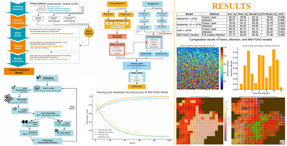
Floods are one of the most frequent hydrometeorological disasters in Indonesia, causing severe social, economic, and environmental impacts. The object of this research is spatio-temporal flood detection in Simpang Empat, Asahan Regency, North Sumatra, an area that faces annual flooding due to high rainfall, low-lying topography, and land-use changes. Conventional detection approaches based on either spatial or temporal data often fail to capture complex interactions, thereby limiting predictive accuracy. To address this problem, this study developed a multi-modal fully guided attention gate (MM-FGAG) framework that integrates Sentinel-2 multispectral imagery, SRTM elevation, CHIRPS rainfall, and ERA5 atmospheric variables. The model employs CNN-based spatial priors to guide temporal attention in LSTM, ensuring that predictions focus on the most flood-relevant regions and time periods. Experimental results show that MM-FGAG achieved 91.72% accuracy, 92.05% precision, 90.29% recall, and an AUC of 0.945, significantly outperforming CNN, LSTM, and CNN-LSTM baselines. This improvement is explained by explicit spatial-to-temporal guidance, which enhances predictive accuracy while also increasing interpretability through attention maps. Distinctive features of the framework include multimodal integration, guided attention, and the ability to generate flood risk maps with more than 90% agreement with observed data. These findings confirm that MM-FGAG is robust, adaptive, and capable of producing accurate and explainable predictions. The framework shows strong potential for use in flood early warning systems and disaster risk management, providing timely information for evacuation planning and resource allocation in vulnerable regions.
References
- Gosset, M., Dibi-Anoh, P. A., Schumann, G., Hostache, R., Paris, A., Zahiri, E.-P. et al. (2023). Hydrometeorological Extreme Events in Africa: The Role of Satellite Observations for Monitoring Pluvial and Fluvial Flood Risk. Surveys in Geophysics, 44 (1), 197–223. https://doi.org/10.1007/s10712-022-09749-6
- Hermawan, E., Risyanto, R., Purwaningsih, A., Ratri, D. N., Ridho, A., Harjana, T. et al. (2024). Characteristics of Mesoscale Convective Systems and Their Impact on Heavy Rainfall in Indonesia’s New Capital City, Nusantara, in March 2022. Advances in Atmospheric Sciences, 42 (2), 342–356. https://doi.org/10.1007/s00376-024-4102-1
- Taye, M. T., Dyer, E. (2024). Hydrologic Extremes in a Changing Climate: a Review of Extremes in East Africa. Current Climate Change Reports, 10 (1), 1–11. https://doi.org/10.1007/s40641-024-00193-9
- Abegaz, R., Wang, F., Xu, J. (2024). History, causes, and trend of floods in the U.S.: a review. Natural Hazards, 120 (15), 13715–13755. https://doi.org/10.1007/s11069-024-06791-y
- Waleed, M., Sajjad, M. (2023). On the emergence of geospatial cloud-based platforms for disaster risk management: A global scientometric review of google earth engine applications. International Journal of Disaster Risk Reduction, 97, 104056. https://doi.org/10.1016/j.ijdrr.2023.104056
- Luk, S. Y., Sajjad, M. (2025). From space to screen: Recent advances in remote sensing for mangrove valuation through a bibliometric lens. Ocean & Coastal Management, 269, 107844. https://doi.org/10.1016/j.ocecoaman.2025.107844
- Asiyabi, R. M., Ghorbanian, A., Tameh, S. N., Amani, M., Jin, S., Mohammadzadeh, A. (2023). Synthetic Aperture Radar (SAR) for Ocean: A Review. IEEE Journal of Selected Topics in Applied Earth Observations and Remote Sensing, 16, 9106–9138. https://doi.org/10.1109/jstars.2023.3310363
- Du, R., Xiang, Y., Chen, J., Lu, X., Zhang, F., Zhang, Z. et al. (2024). The daily soil water content monitoring of cropland in irrigation area using Sentinel-2/3 spatio-temporal fusion and machine learning. International Journal of Applied Earth Observation and Geoinformation, 132, 104081. https://doi.org/10.1016/j.jag.2024.104081
- Pareta, K. (2023). Hydrological modelling of largest braided river of India using MIKE Hydro River software with rainfall runoff, hydrodynamic and snowmelt modules. Journal of Water and Climate Change, 14 (4), 1314–1338. https://doi.org/10.2166/wcc.2023.484
- Li, J., Wu, G., Zhang, Y., Shi, W. (2024). Optimizing flood predictions by integrating LSTM and physical-based models with mixed historical and simulated data. Heliyon, 10 (13), e33669. https://doi.org/10.1016/j.heliyon.2024.e33669
- Ke, E., Zhao, J., Zhao, Y. (2025). Investigating the influence of nonlinear spatial heterogeneity in urban flooding factors using geographic explainable artificial intelligence. Journal of Hydrology, 648, 132398. https://doi.org/10.1016/j.jhydrol.2024.132398
- Zhao, B., Sui, H., Liu, J., Shi, W., Wang, W., Xu, C., Wang, J. (2024). Flood inundation monitoring using multi-source satellite imagery: a knowledge transfer strategy for heterogeneous image change detection. Remote Sensing of Environment, 314, 114373. https://doi.org/10.1016/j.rse.2024.114373
- Bagheri, A., Liu, G.-J. (2025). Climate change and urban flooding: assessing remote sensing data and flood modeling techniques: a comprehensive review. Environmental Reviews, 33, 1–14. https://doi.org/10.1139/er-2024-0065
- Qatrinnada, W. F. P., Hidayah, E., Halik, G., Wiyono, R. U. A. (2024). A literature review: rainfall thresholds as flash flood monitoring for an early warning system. Water Practice & Technology, 19 (11), 4486–4498. https://doi.org/10.2166/wpt.2024.271
- Huang, X., Chen, N., Deng, Z., Huang, S. (2024). Multivariate time series anomaly detection via dynamic graph attention network and Informer. Applied Intelligence, 54 (17-18), 7636–7658. https://doi.org/10.1007/s10489-024-05575-y
- Maddah, S., Mojaradi, B., Alizadeh, H. (2024). Enhancing flood susceptibility modeling using integration of multi-source satellite imagery and multi-input convolutional neural network. Natural Hazards, 121 (3), 2801–2824. https://doi.org/10.1007/s11069-024-06764-1
- Fu, Y., Zhu, Z., Liu, L., Zhan, W., He, T., Shen, H. et al. (2024). Remote Sensing Time Series Analysis: A Review of Data and Applications. Journal of Remote Sensing, 4. https://doi.org/10.34133/remotesensing.0285
- Islam, K., Daraio, J. A., Cheema, M., Sabau, G., Galagedara, L. (2025). Improved streamflow prediction accuracy in Boreal climate watershed using a LSTM model: A comparative study. PLOS Water, 4 (4), e0000359. https://doi.org/10.1371/journal.pwat.0000359
- He, X., Zhang, S., Xue, B., Zhao, T., Wu, T. (2023). Cross-modal change detection flood extraction based on convolutional neural network. International Journal of Applied Earth Observation and Geoinformation, 117, 103197. https://doi.org/10.1016/j.jag.2023.103197
- Chen, Z., Lin, H., Shen, G. (2023). TreeLSTM: A spatiotemporal machine learning model for rainfall-runoff estimation. Journal of Hydrology: Regional Studies, 48, 101474. https://doi.org/10.1016/j.ejrh.2023.101474
- Farahmand, H., Xu, Y., Mostafavi, A. (2023). A spatial–temporal graph deep learning model for urban flood nowcasting leveraging heterogeneous community features. Scientific Reports, 13 (1). https://doi.org/10.1038/s41598-023-32548-x
- Li, J., Jin, C., Shen, Y., Ye, W. (2024). TRSANet: A Remote Sensing Deep Learning Model for Water Body Change Detection Based on Time-Reversal Semantic Asymmetry. IEEE Transactions on Geoscience and Remote Sensing, 62, 1–13. https://doi.org/10.1109/tgrs.2024.3458951
- Oddo, P. C., Bolten, J. D., Kumar, S. V., Cleary, B. (2024). Deep Convolutional LSTM for improved flash flood prediction. Frontiers in Water, 6. https://doi.org/10.3389/frwa.2024.1346104
- Wang, Z., Lyu, H., Fu, G., Zhang, C. (2024). Time-guided convolutional neural networks for spatiotemporal urban flood modelling. Journal of Hydrology, 645, 132250. https://doi.org/10.1016/j.jhydrol.2024.132250
- Saleh, T., Holail, S., Zahran, M., Xiao, X., Xia, G.-S. (2024). LiST-Net: Enhanced Flood Mapping With Lightweight SAR Transformer Network and Dimension-Wise Attention. IEEE Transactions on Geoscience and Remote Sensing, 62, 1–17. https://doi.org/10.1109/tgrs.2024.3397797
- Mondal, G., Dhanaraj, R. K. (2025). A novel multi-model fused classification for classifying the natural disaster. Progress in Artificial Intelligence. https://doi.org/10.1007/s13748-025-00388-7
- Chen, C., Zhang, D., Qi, X., Wang, Z., Xiang, L. (2025). GKASA–DDPM: a novel flood forecasting model based on Graph Kolmogorov–Arnold Attention and spatio-temporal attention under smoothing DDPM. Journal of Hydroinformatics, 27 (3), 560–579. https://doi.org/10.2166/hydro.2025.312
- Cui, Y., Duan, P., Li, J. (2025). PDSDC: Progressive Spatiotemporal Difference Capture Network for Remote Sensing Change Detection. IEEE Journal of Selected Topics in Applied Earth Observations and Remote Sensing, 18, 16879–16895. https://doi.org/10.1109/jstars.2025.3569128
- Zhang, Q., Zhang, X., Quan, C., Zhao, T., Huo, W., Huang, Y. (2025). Mamba-STFM: A Mamba-Based Spatiotemporal Fusion Method for Remote Sensing Images. Remote Sensing, 17 (13), 2135. https://doi.org/10.3390/rs17132135
- Wanto, A., Yuhandri, Y., Okfalisa, O. (2024). RetMobileNet: A New Deep Learning Approach for Multi-Class Eye Disease Identification. Revue d’Intelligence Artificielle, 38 (4). https://doi.org/10.18280/ria.380401
Downloads
Published
How to Cite
Issue
Section
License
Copyright (c) 2025 Neni Mulyani, Anjar Wanto, Jhonson Efendi Hutagalung

This work is licensed under a Creative Commons Attribution 4.0 International License.
The consolidation and conditions for the transfer of copyright (identification of authorship) is carried out in the License Agreement. In particular, the authors reserve the right to the authorship of their manuscript and transfer the first publication of this work to the journal under the terms of the Creative Commons CC BY license. At the same time, they have the right to conclude on their own additional agreements concerning the non-exclusive distribution of the work in the form in which it was published by this journal, but provided that the link to the first publication of the article in this journal is preserved.
A license agreement is a document in which the author warrants that he/she owns all copyright for the work (manuscript, article, etc.).
The authors, signing the License Agreement with TECHNOLOGY CENTER PC, have all rights to the further use of their work, provided that they link to our edition in which the work was published.
According to the terms of the License Agreement, the Publisher TECHNOLOGY CENTER PC does not take away your copyrights and receives permission from the authors to use and dissemination of the publication through the world's scientific resources (own electronic resources, scientometric databases, repositories, libraries, etc.).
In the absence of a signed License Agreement or in the absence of this agreement of identifiers allowing to identify the identity of the author, the editors have no right to work with the manuscript.
It is important to remember that there is another type of agreement between authors and publishers – when copyright is transferred from the authors to the publisher. In this case, the authors lose ownership of their work and may not use it in any way.


